IMAGES TAKEN NEAR TO
Broadway, BOURNEMOUTH, BH6 4EG
Introduction
This page details the photographs taken nearby to Broadway, BH6 4EG by members of the Geograph project.
The Geograph project started in 2005 with the aim of publishing, organising and preserving representative images for every square kilometre of Great Britain, Ireland and the Isle of Man.

There are currently over 7.5m images from over14,400 individuals and you can help contribute to the project by visiting https://www.geograph.org.uk
Image Map
Images are licensed for reuse under creativecommons.org/licenses/by-sa/2.0
Notes
- Clicking on the map will re-center to the selected point.
- The higher the marker number, the further away the image location is from the centre of the postcode.
Image Listing (28 Images Found)
Images are licensed for reuse under creativecommons.org/licenses/by-sa/2.0
Image
Details
Distance
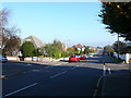
2
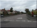
Junction of Nugent Road with Broadway, Southbourne
Image: © David Smith
Taken: 25 Jan 2018
0.06 miles
3
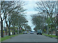
Bournemouth : Broadway
Looking along Broadway in Bournemouth.
Image: © Lewis Clarke
Taken: 27 Mar 2018
0.08 miles
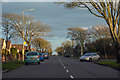
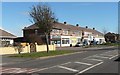
4
Broadway, Southbourne
Housing laid out with spacious roads and gardens
Image: © David Smith
Taken: 25 Jan 2018
0.09 miles
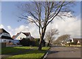
5
Wildown Rd
This long residential road with many bungalows and detached houses runs from Church Rd north across Southbourne to Broadway.
Image: © Nigel Mykura
Taken: 15 Nov 2011
0.15 miles
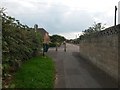
6
Wick: bridleway I28 has a No Cycling sign
This is the start of the public right of way leading to Branders Close. It is, according to all relevant maps (including data from the Local Authority's definitive map), designated as a public bridleway.
However, it has a No Cycling sign at this end, which would be appropriate if this were a public footpath rather than a public bridleway. The red perimeter circle of the sign has faded almost to non-existence and is on a substantially rusting pole, suggesting that it has been there very many years.
See Image] for the next photo along the bridleway, with links to further photos along the route.
Image: © Chris Downer
Taken: 24 Sep 2016
0.15 miles
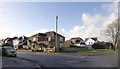
7
Southbourne: Broadway shops
A small parade of shops in Broadway, Southbourne, a few of which have no survived as businesses. Among the shops on offer are a general stores and post office, a Chinese takeaway, and a kite shop.
Image: © Chris Downer
Taken: 9 Mar 2008
0.16 miles
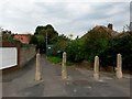
8
Wick: bridleway I28 emerges onto Thornbury Road
Looking along the southern end of this short public bridleway from Branders Close, as it arrives onto Thornbury Road. Belfield Road is directly opposite - well, a yard or two off-straight.
See Image] for the view towards us from the end of the bridleway, and Image for the next view on the path behind us, with links to further pictures along the route.
Image: © Chris Downer
Taken: 24 Sep 2016
0.16 miles
9
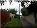
Wick: towards the southern end of bridleway I28
This short bridleway is more footpath-like and it runs between the dead end of Branders Close (behind us) and Thornbury Road. We see it as it approaches the latter, with some green utility box ahead on the grass abutting the path.
See Image for the next view along the path ahead, and Image for the next behind us, with links to further photos along the route.
Image: © Chris Downer
Taken: 24 Sep 2016
0.16 miles
10
Southbourne: postbox № BH6 328, Riversdale Road
Riversdale Road, like its neighbours, comprises rather desirable bungalows, and it also has this Elizabeth II-reign postbox at its southern end.
Image: © Chris Downer
Taken: 6 Sep 2008
0.16 miles