IMAGES TAKEN NEAR TO
Latch Farm Avenue, CHRISTCHURCH, BH23 2UD
Introduction
This page details the photographs taken nearby to Latch Farm Avenue, BH23 2UD by members of the Geograph project.
The Geograph project started in 2005 with the aim of publishing, organising and preserving representative images for every square kilometre of Great Britain, Ireland and the Isle of Man.

There are currently over 7.5m images from over14,400 individuals and you can help contribute to the project by visiting https://www.geograph.org.uk
Image Map
Images are licensed for reuse under creativecommons.org/licenses/by-sa/2.0
Notes
- Clicking on the map will re-center to the selected point.
- The higher the marker number, the further away the image location is from the centre of the postcode.
Image Listing (34 Images Found)
Images are licensed for reuse under creativecommons.org/licenses/by-sa/2.0
Image
Details
Distance
1
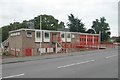
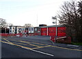
Christchurch Fire Station
Christchurch Fire Station, Fairmile Road, Christchurch, Dorset.
Image: © Kevin Hale
Taken: 27 Sep 2006
0.07 miles
2
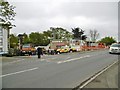
Christchurch Fire Station
On Fairmile Road. Today was the station's open day, with an impressive exhibition of hardware and demonstrations: http://www.dorsetfire.gov.uk/events/christchurch-open-day/
Image: © Mike Faherty
Taken: 26 Apr 2015
0.07 miles
5
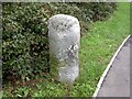
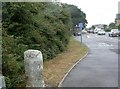
Old Boundary Marker by the B3073, Fairmile Road, Christchurch
Parish Boundary Marker by the B3073, in parish of Christchurch (Christchurch District), Fairmile Road, 32m South of roundabout.
N.B. Listed as a milestone, but the 1888 O.S. map shows it as a 'BS' on the Municipal Boundary.
Grade II listed.
List Entry Number: 1110100 https://historicengland.org.uk/listing/the-list/list-entry/1110100
Surveyed
Milestone Society National ID: HA_CHRpb
Image: © Milestone Society
Taken: Unknown
0.11 miles
6
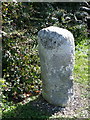
Boundary stone, Christchurch
For a wider view of the stone http://www.geograph.org.uk/photo/2083785
Image: © Maigheach-gheal
Taken: 26 Sep 2010
0.11 miles
7
Boundary stone, Christchurch
Standing beside the B3073 is an old parish boundary stone.
Image: © Maigheach-gheal
Taken: 26 Sep 2010
0.11 miles
8
Christchurch, boundary stone
On Fairmile Road, marking the original boundary of the borough; possibly dating from C17.
Image: © Mike Faherty
Taken: 6 Aug 2010
0.11 miles
9
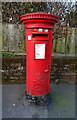
Elizabeth II postbox on Fairmile Road
Postbox No. BH23 24.
Image: © JThomas
Taken: 23 Mar 2022
0.13 miles
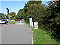
10
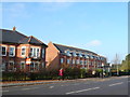
Clarence Place
This is a large development of houses and apartments just off Fairmile Rd built in an unusual curving formation. Taken from the other side of Fairmile Rd close to the junction with Knap Hill Avenue.
Image: © Nigel Mykura
Taken: 15 Nov 2011
0.13 miles