IMAGES TAKEN NEAR TO
Sycamore Close, WAREHAM, BH20 7QP
Introduction
This page details the photographs taken nearby to Sycamore Close, BH20 7QP by members of the Geograph project.
The Geograph project started in 2005 with the aim of publishing, organising and preserving representative images for every square kilometre of Great Britain, Ireland and the Isle of Man.

There are currently over 7.5m images from over14,400 individuals and you can help contribute to the project by visiting https://www.geograph.org.uk
Image Map
Images are licensed for reuse under creativecommons.org/licenses/by-sa/2.0
Notes
- Clicking on the map will re-center to the selected point.
- The higher the marker number, the further away the image location is from the centre of the postcode.
Image Listing (20 Images Found)
Images are licensed for reuse under creativecommons.org/licenses/by-sa/2.0
Image
Details
Distance
1
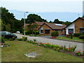
Sandford: postbox № BH20 89, Woodlands Drive
This postbox serves a medium-sized, modern housing estate just off the main road (the roundabout is visible in the distance). It is emptied finally at 5:15pm on weekdays and the surprisingly early 7:30am on Saturdays.
Image: © Chris Downer
Taken: 17 Jan 2009
0.09 miles
2
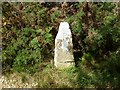
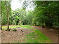
Old Boundary Marker in woodland, Wareham St Martin parish
Estate Boundary Marker by the footpath, in parish of Wareham St Martin (Purbeck District), Roman Road, in woodland.
Surveyed
Milestone Society National ID: DO_SAND06em
Image: © Milestone Society
Taken: Unknown
0.12 miles
4
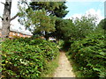
Sandford, footpath
From Sandford to Holton Heath, with housing to the left, and woodland to the right. The path is known as "Roman Road"; an archaeological investigation is shortly due to investigate whether this name is correct.
Image: © Mike Faherty
Taken: 6 Aug 2011
0.16 miles
5
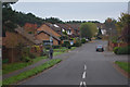
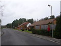
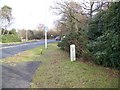
Sandford : Woodlands Drive
Along Woodlands Drive as it heads off from Sandford Road.
Image: © Lewis Clarke
Taken: 28 Oct 2017
0.16 miles
6
Sandford Heath, woodland
Near the entrance to the National Nature Reserve. The beeches to the right were apparently planted by an early C18 landowner as part of a tree nursery. http://www.dorsetforyou.com/399711
Image: © Mike Faherty
Taken: 31 Jul 2011
0.16 miles
7
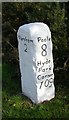
Old Milestone by the A351, north east of Wareham
Carved stone post by the A351, in parish of WAREHAM ST MARTIN (PURBECK District), near roundabout by Sandford Middle School, on wide verge on northern exit from roundabout, on East side of road. Dorset 3 (Rounded top), erected by the Poole turnpike trust in the 19th century.
Inscription reads:-
: Wareham / 2 : : Poole / 8 / Hyde / Park / Corner / 109 :
Carved benchmark bottom centre of front face.
Milestone Society National ID: DO_WAPO02.
Image: © J Tybjerg
Taken: 18 Jun 2002
0.17 miles
8
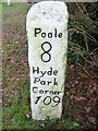
Milestone, Sandford
Milestone beside the A351, near Sandford. The legend reads Poole 8, Hyde Park Corner 109. For a wider view see Image
Image: © Maigheach-gheal
Taken: 31 Jan 2010
0.18 miles
9
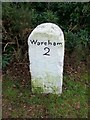
Milestone, Sandford
Milestone beside the A351, near Sandford. The Legend reads Wareham 2. For a wider view see Image There is an OS cut mark benchmark at the bottom of the NW face. Old maps show this as BM 31.4ft (1890, 1902) and 30.5ft (1925) for Wareham 2, Poole 8. See http://www.bench-marks.org.uk/bm33399 for additional information.
Image: © Maigheach-gheal
Taken: 31 Jan 2010
0.18 miles
10
Milestone, Sandford
Milestone beside the A351, near Sandford.
Image: © Maigheach-gheal
Taken: 31 Jan 2010
0.18 miles