IMAGES TAKEN NEAR TO
Corfe Lodge Road, BROADSTONE, BH18 9NF
Introduction
This page details the photographs taken nearby to Corfe Lodge Road, BH18 9NF by members of the Geograph project.
The Geograph project started in 2005 with the aim of publishing, organising and preserving representative images for every square kilometre of Great Britain, Ireland and the Isle of Man.

There are currently over 7.5m images from over14,400 individuals and you can help contribute to the project by visiting https://www.geograph.org.uk
Image Map
Images are licensed for reuse under creativecommons.org/licenses/by-sa/2.0
Notes
- Clicking on the map will re-center to the selected point.
- The higher the marker number, the further away the image location is from the centre of the postcode.
Image Listing (12 Images Found)
Images are licensed for reuse under creativecommons.org/licenses/by-sa/2.0
Image
Details
Distance
1
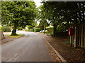
Corfe Mullen: postbox № BH18 118, Corfe Lodge Road
This bit of Corfe Mullen marks a little postal boundary anomaly. The Roman Road, just to the east, marks the boundary of Corfe Mullen (in East Dorset and mostly the BH21 postcode district) and Broadstone (in Poole and BH18).
However, since this bit of Corfe Mullen is accessible only by crossing Roman Road, it quite logically receives its post via Broadstone.
We thus have the situation that the properties in Corfe Lodge Road pay their council tax to East Dorset but have letters addressed as Broadstone.
The postbox is emptied finally at 5:15pm on weekdays and at 11:45am on Saturdays.
Image: © Chris Downer
Taken: 12 Jul 2009
0.02 miles
2
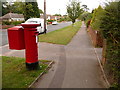
Broadstone: postbox № BH18 146, Clarendon Road
This Elizabeth II-reign postbox stands at the western end of Clarendon Road, with Roman Road immediately behind us – the latter is also the boundary of Poole borough and East Dorset district.
The box is emptied finally at 5:30pm on weekdays and at 11:45am on Saturdays.
Image: © Chris Downer
Taken: 12 Jul 2009
0.17 miles
3
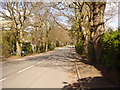
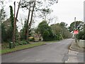
Roman Road, Broadstone.
No actual Romans, but very straight.
Image: © Simon Scurr
Taken: 19 Mar 2007
0.17 miles
4
Upton, Beacon Gardens
Off Beacon Road.
Image: © Mike Faherty
Taken: 14 Jun 2011
0.18 miles
5
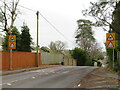
Upton, Roman Road
On the site of the Roman road from Hamworthy to Badbury; The road also forms the boundary between East Dorset (left), and Poole (right).
Image: © Mike Faherty
Taken: 14 Jun 2011
0.20 miles
6
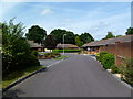
Clarendon Road, Broadstone
The photographer did look left, right and left again before stepping out to capture this shot.
Image: © Simon Scurr
Taken: 19 Mar 2007
0.22 miles
7
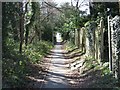
Roman Road, Broadstone
The actual Roman Road is just to the left of this track, but parallel to it,
you can still see the aggar I think
Image: © John Palmer
Taken: 30 Mar 2009
0.22 miles
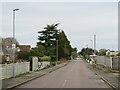
8
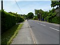
Springdale Road, Corfe Mullen
Springdale Road in Corfe Mullen, near Poole. Here the road starts to go down a hill. Road signs warn motorists to expect cyclists and horse riders on the road ahead, as a bridle path crosses the road a short distance away.
Image: © Malc McDonald
Taken: 7 Feb 2022
0.22 miles
9
Springdale Road, Corfe Mullen
Springdale Road in Corfe Mullen, near Poole.
Image: © Malc McDonald
Taken: 7 Feb 2022
0.23 miles
10
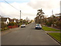
Highfield Road, Corfe Mullen
Highfield Road is a residential road in Corfe Mullen, near Poole.
Image: © Malc McDonald
Taken: 7 Feb 2022
0.24 miles