IMAGES TAKEN NEAR TO
Hop Close, POOLE, BH16 5RG
Introduction
This page details the photographs taken nearby to Hop Close, BH16 5RG by members of the Geograph project.
The Geograph project started in 2005 with the aim of publishing, organising and preserving representative images for every square kilometre of Great Britain, Ireland and the Isle of Man.

There are currently over 7.5m images from over14,400 individuals and you can help contribute to the project by visiting https://www.geograph.org.uk
Image Map (Loading...)


Getting Data...Please wait
Leaflet Map data © OpenStreetMap
Images are licensed for reuse under creativecommons.org/licenses/by-sa/2.0
Notes
- Clicking on the map will re-center to the selected point.
- The higher the marker number, the further away the image location is from the centre of the postcode.
Image Listing (17 Images Found)
Images are licensed for reuse under creativecommons.org/licenses/by-sa/2.0
Image
Details
Distance
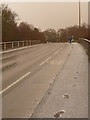
1
Lytchett Minster: the A35 in sleet
Not ten minutes ago it was a sunny day a couple of miles south. Now, sleet covers the roads in what appeared to be a very localised flurry of sleet – only a mile or two east it was definitely rain and the roads were not hazardous at all.
The reason for the surprising route of these tyre-marks, all changing lanes at the same point, is an incident that has just occurred out-of-shot to the left – see Image
Image: © Chris Downer
Taken: 20 Feb 2010
0.15 miles
2
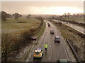
Lytchett Minster: spin-off on the A35
Not ten minutes ago it was a sunny day a couple of miles south. Now, sleet covers the roads in what appeared to be a very localised flurry of sleet – only a mile or two east it was definitely rain and the roads were not hazardous at all.
The sudden icy conditions seem to have caused a few incidents, as a number of ambulances and police cars were going around with blue lights flashing and sirens on. Here, someone has slid off the road and the police have just this second arrived.
Image: © Chris Downer
Taken: 20 Feb 2010
0.16 miles
3
Upton, Beach Road
Unadopted road with bridleway, from Sandy Lane to reedbeds at Lytchett Bay, seen in the distance. No beach visible!
Image: © Mike Faherty
Taken: 27 Feb 2010
0.16 miles
4
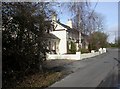
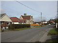
Upton, Laurel Cottage
At the northern end of Slough Lane, looking mostly a lot older than other nearby properties.
Image: © Mike Faherty
Taken: 27 Feb 2010
0.16 miles
5
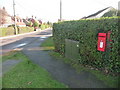
Upton: postbox № BH16 208, Sandy Lane
This little postbox is attached to a wooden post, painted red, hidden in a hedge on the corner of Slough Lane. It is emptied finally at 5:30pm on weekdays and at 11am on Saturdays.
Image: © Chris Downer
Taken: 15 Nov 2009
0.17 miles
6
Upton: sleet on Policeman?s Lane junction
Not ten minutes ago it was a sunny day a couple of miles south. Now, sleet covers the roads in what appeared to be a very localised flurry of sleet – only a mile or two east it was definitely rain and the roads were not hazardous at all.
Image: © Chris Downer
Taken: 20 Feb 2010
0.17 miles
7
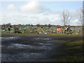
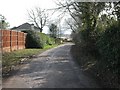
Upton, allotments
Off Slough Lane, maintained by the parish council.
Image: © Mike Faherty
Taken: 27 Feb 2010
0.17 miles
8
Upton, Lady Wimborne Cottages
Near the southern end of Sea View Road. A pair from about 110 estate cottages built by Lady Wimborne and her daughter between 1867 and 1904. Cottages have relief brick numbers above the front door; confusingly, these are not street house numbers, but serial numbers. This pair is numbered 96 & 97, and dated 1895. http://archive.dorsetecho.co.uk/2000/11/6/109091.html
Image: © Mike Faherty
Taken: 27 Feb 2010
0.17 miles
9
Lytchett Minster: footprints in the sleet
Not ten minutes ago it was a sunny day a couple of miles south. Now, sleet covers the roads in what appeared to be a very localised flurry of sleet – only a mile or two east it was definitely rain and the roads were not hazardous at all.
Where cars came along here with the wheels running slightly off the course of previous ones, the spray coming from them was quite impressive and it was a good idea to give them as wide a berth as possible!
Image: © Chris Downer
Taken: 20 Feb 2010
0.17 miles
10
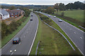
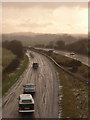
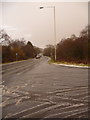
Purbeck : Upton Bypass A35
Looking along the Upton Bypass from the B3067 bridge over it.
Image: © Lewis Clarke
Taken: 28 Oct 2017
0.18 miles