IMAGES TAKEN NEAR TO
Winterbourne Road, POOLE, BH15 2ES
Introduction
This page details the photographs taken nearby to Winterbourne Road, BH15 2ES by members of the Geograph project.
The Geograph project started in 2005 with the aim of publishing, organising and preserving representative images for every square kilometre of Great Britain, Ireland and the Isle of Man.

There are currently over 7.5m images from over14,400 individuals and you can help contribute to the project by visiting https://www.geograph.org.uk
Image Map
Images are licensed for reuse under creativecommons.org/licenses/by-sa/2.0
Notes
- Clicking on the map will re-center to the selected point.
- The higher the marker number, the further away the image location is from the centre of the postcode.
Image Listing (37 Images Found)
Images are licensed for reuse under creativecommons.org/licenses/by-sa/2.0
Image
Details
Distance
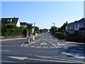
1
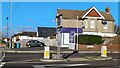
Western end of Pound Lane
The sign in the middle of the junction explains that this was once the site of a pound for impounding cattle, hence the road name. For a close-up view of the sign, see Image
Image: © David Martin
Taken: 6 Jan 2024
0.07 miles
2
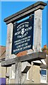
Sign at the end of Pound Lane
"Borough of Poole Site of the ancient pound Longfleet Formerly under the jurisdiction of the Lord of the Manor of Canford". For locational context, see Image
Image: © David Martin
Taken: 6 Jan 2024
0.07 miles
3
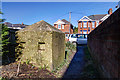
Defending Dorset in 1940: the Maiden Newton - Poole Harbour Stop Line (97)
-
Anti-tank Block: DoB ID: e24910
Poole - Sandbourne Road - Cube. The sole survivor in an alley off Sandbourne Road of a continuous line of similar concrete anti-tank blocks along this street that once extended from Poole Park to Creekmoor.
This is the last photo in the series recording mostly pillboxes and anti-tank cubes on the Stop-Line covering a distance of some 25 to 30 miles, and inevitably ending here in Poole. The Maiden Newton to Poole Harbour Stop Line was but a small part of a colossal anti-invasion undertaking that during 1940-41 embraced the entire country from Lands End to John O'Groats, lines of defence that thankfully never saw a shot fired in anger.
************
BACK TO START: Image
Image: © Mike Searle
Taken: 18 Feb 2016
0.07 miles
4
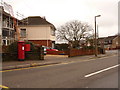
Parkstone: postbox № BH15 57, Pound Lane
This Elizabeth II-reign postbox is emptied finally at 5:30pm on weekdays and at 12:15pm on Saturdays.
Image: © Chris Downer
Taken: 28 Feb 2010
0.09 miles
5

View from Ward B4, Poole Hospital
Not a bad view from a hospital ward!
Image: © Paul Whittington
Taken: 25 Nov 2010
0.09 miles
6
Pound Lane, Poole
The sign reads: "This was used for the impounding of straying cattle controlled by haywards appointed by the annual court leet of the manor of Canford".
Image: © Stuart Shepherd
Taken: 16 Aug 2010
0.10 miles
7

View from Ward B4, Poole Hospital, at night
The lights of Poole (Oakdale).
Image: © Paul Whittington
Taken: 25 Nov 2010
0.10 miles
8
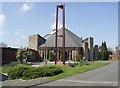
St Mary's Roman Catholic Church
It was built in 1973, and has a stand-alone metal bell tower in front.
Image: © mike smith
Taken: 9 Apr 2007
0.12 miles
9
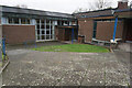
Turf Zone "CatholicMary"
St Mary's Church Hall on Wimborne Road, Poole.
Image: © Ian S
Taken: 16 Nov 2022
0.12 miles
10
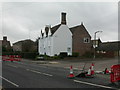
Poole, Henning's Farm
On Fernside Road; a house with outbuildings to the rear, obviously out of character with its mainly post-war surroundings. Looking at old OS maps, this was Henning's Farm.
Image: © Mike Faherty
Taken: 8 Nov 2009
0.12 miles