Defending Dorset in 1940: the Maiden Newton - Poole Harbour Stop Line (97)
Introduction
The photograph on this page of Defending Dorset in 1940: the Maiden Newton - Poole Harbour Stop Line (97) by Mike Searle as part of the Geograph project.
The Geograph project started in 2005 with the aim of publishing, organising and preserving representative images for every square kilometre of Great Britain, Ireland and the Isle of Man.

There are currently over 7.5m images from over 14,400 individuals and you can help contribute to the project by visiting https://www.geograph.org.uk
Defending Dorset in 1940: the Maiden Newton - Poole Harbour Stop Line (97)
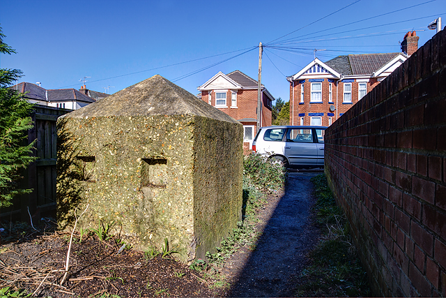
Image: © Mike Searle Taken: 18 Feb 2016
- Anti-tank Block: DoB ID: e24910 Poole - Sandbourne Road - Cube. The sole survivor in an alley off Sandbourne Road of a continuous line of similar concrete anti-tank blocks along this street that once extended from Poole Park to Creekmoor. This is the last photo in the series recording mostly pillboxes and anti-tank cubes on the Stop-Line covering a distance of some 25 to 30 miles, and inevitably ending here in Poole. The Maiden Newton to Poole Harbour Stop Line was but a small part of a colossal anti-invasion undertaking that during 1940-41 embraced the entire country from Lands End to John O'Groats, lines of defence that thankfully never saw a shot fired in anger. ************ BACK TO START: Image
Images are licensed for reuse under creativecommons.org/licenses/by-sa/2.0
Image Location
Latitude
50.726808
Longitude
-1.976146