IMAGES TAKEN NEAR TO
Loewy Crescent, POOLE, BH12 4PQ
Introduction
This page details the photographs taken nearby to Loewy Crescent, BH12 4PQ by members of the Geograph project.
The Geograph project started in 2005 with the aim of publishing, organising and preserving representative images for every square kilometre of Great Britain, Ireland and the Isle of Man.

There are currently over 7.5m images from over14,400 individuals and you can help contribute to the project by visiting https://www.geograph.org.uk
Image Map
Images are licensed for reuse under creativecommons.org/licenses/by-sa/2.0
Notes
- Clicking on the map will re-center to the selected point.
- The higher the marker number, the further away the image location is from the centre of the postcode.
Image Listing (63 Images Found)
Images are licensed for reuse under creativecommons.org/licenses/by-sa/2.0
Image
Details
Distance
1
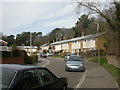
Alderney, Loewy Crescent
Terraced housing in Loewy Crescent. Although the road backs onto Bourne Valley Nature Reserve, the roar of traffic from nearby Ringwood Road is always present.
Image: © Mike Faherty
Taken: 7 Mar 2009
0.03 miles
2
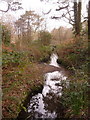
Bourne Valley Nature Reserve, the Bourne
Bourne Stream, seen from the edge of woodland near Ringwood Road. For 3km, Bourne Valley is a nature reserve, with various habitats & conservation designations. http://www.bournestreampartnership.org.uk/bourne_valley_lnr.htm
Image: © Mike Faherty
Taken: 7 Mar 2009
0.04 miles
3
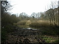
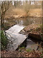
Bourne Valley Nature Reserve, pond
Bourne Valley NR is situated along a narrow valley of the Bourne Stream, which flows from near Canford Heath and enters the sea at Bournemouth Pier. The reserve extends for 3km, and has various conservation designations, here, SSSI.http://www.bournestreampartnership.org.uk/bv_sssi.htm
Image: © Mike Faherty
Taken: 7 Mar 2009
0.04 miles
4

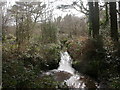
Alderney: footbridge at Bourne Bottom
This metal bridge crosses the Bourne Stream early on its journey – it will reach the coast after a few miles, at Bournemouth pier.
Image: © Chris Downer
Taken: 14 Feb 2010
0.06 miles
5
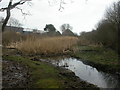
Bourne Valley Nature Reserve, bog pool
Bourne Valley Nature Reserve is linear, and extends for 3km along the deep valley of the Bourne, seen here entering a stretch of bog, with dense bulrushes; buildings from Discovery Court Industrial Estate in the background to the left.http://www.bournestreampartnership.org.uk/bourne_valley_lnr.htm
Image: © Mike Faherty
Taken: 7 Mar 2009
0.06 miles
6

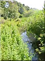
Alderney, wetland
Along Bourne Stream, with Yellow Iris (Iris pseudacorus) and Hemlock Water Dropwort (Oenanthe crocata) in flower.
Image: © Mike Faherty
Taken: 14 Jun 2013
0.06 miles
7
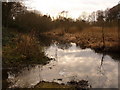
Alderney: a youthful Bourne stream
We look downstream along the Bourne stream, just after it has commenced its gentle journey of a few miles to Bournemouth pier.
Image: © Chris Downer
Taken: 14 Feb 2010
0.06 miles
8
Alderney, Bourne Stream
Rising on Canford Heath and flowing into the sea near Bournemouth Pier. An idyllic site, sandwiched between suburban housing and light industry: http://www.boroughofpoole.com/environment/countryside/bourne-valley-nature-reserve/
Image: © Mike Faherty
Taken: 2 Jul 2014
0.06 miles
9
Alderney: odd waterfall arrangement on the Bourne stream
In the background is the Image, and here the water is feeding into the Bourne stream. It is going down what almost appears to be a makeshift waterfall.
Image: © Chris Downer
Taken: 14 Feb 2010
0.07 miles
10
Alderney: pool of water by the Bourne stream
The Bourne stream, here having just started its journey, enters soggy, marshy land here and this pool feeds from and back into it. A Tesco carrier bag is marooned against underwater vegetation in the foreground – 'Every little hinders' in this case.
Image: © Chris Downer
Taken: 14 Feb 2010
0.07 miles