IMAGES TAKEN NEAR TO
Walliscott Road, BOURNEMOUTH, BH11 8RS
Introduction
This page details the photographs taken nearby to Walliscott Road, BH11 8RS by members of the Geograph project.
The Geograph project started in 2005 with the aim of publishing, organising and preserving representative images for every square kilometre of Great Britain, Ireland and the Isle of Man.

There are currently over 7.5m images from over14,400 individuals and you can help contribute to the project by visiting https://www.geograph.org.uk
Image Map (Loading...)


Getting Data...Please wait
Leaflet Map data © OpenStreetMap
Images are licensed for reuse under creativecommons.org/licenses/by-sa/2.0
Notes
- Clicking on the map will re-center to the selected point.
- The higher the marker number, the further away the image location is from the centre of the postcode.
Image Listing (56 Images Found)
Images are licensed for reuse under creativecommons.org/licenses/by-sa/2.0
Image
Details
Distance
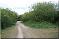
1
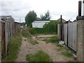
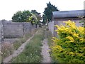
Wallisdown: western end of footpath U18
This public footpath is essentially a rear garage driveway for houses in Canford Avenue and Walliscott Road. Given the height of the grass down the middle, it is perhaps not very heavily used as a driveway.
See Image for the view along the driveway from across the road, and Image for the next view behind us.
Image: © Chris Downer
Taken: 12 Jul 2016
0.05 miles
2
Wallisdown: footpath U18 from Sunnymoor Road
This public footpath takes the course of a rear garage driveway - track might be a better description, being a gravel drive with grass growing down the middle.
It doesn't really offer much of a short-cut compared with walking along Canford Avenue to the left or Walliscott Road to the right, but it comes out on another footpath, number U16, which connects various nearby roads.
See Image for the view towards us from along the driveway, and links to further pictures on the route.
Image: © Chris Downer
Taken: 12 Jul 2016
0.06 miles
3
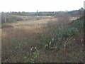
Tussock Bog, Turbary Common
A valley mire, home to butterworts & sundews. As seen from Canford Avenue; in the foreground, straying buddleias; in the middle distance, reed beds & the bog.
http://www.english-nature.org.uk/citation/citation_photo/1001949.pdf
Image: © Mike Faherty
Taken: 8 Dec 2008
0.06 miles
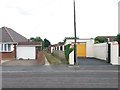
4
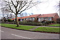
Canford Avenue
This little terrace of single storey small houses looks across Canford Avenue onto the open space of Turbary Common which is the largest area of heathland in north Bournemouth and a Site of Special Scientific Interest.
Image: © Nigel Mykura
Taken: 7 Feb 2019
0.06 miles
5
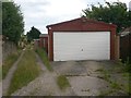
Wallisdown: a garage on footpath U18
This public footpath also serves as a rear garage driveway for houses in Walliscott Road and Canford Avenue, but the length of the grass down the middle and the state of some of the garages suggest that it may not be much used for this purpose. The garage on our right is an exception.
See Image for the next view along the path ahead, and Image for the next view behind us.
Image: © Chris Downer
Taken: 12 Jul 2016
0.07 miles
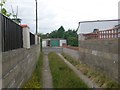
6
Wallisdown: rear accesses on footpath U18
This public footpath also serves as a rear garage driveway for houses in Walliscott Road (left) and Canford Avenue, but the length of the grass down the middle and the state of some of the garages suggest that it may not be much used for this purpose.
See Image for the next view along the path ahead, and Image for the next view behind us.
Image: © Chris Downer
Taken: 12 Jul 2016
0.08 miles
7
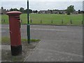
Wallisdown: postbox № BH11 44, Canford Avenue
Looking across the football field beyond.
Image: © Chris Downer
Taken: 17 Aug 2008
0.08 miles
8
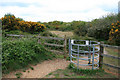
Kissing gate onto Turbary Common
At its most colourful with the gorse in flower.
Image: © David Lally
Taken: 15 May 2010
0.09 miles
9
Wallisdown: eastbound along footpath U18
This public footpath also serves as a rear garage driveway for houses in Walliscott Road and Canford Avenue, but the length of the grass down the middle and the state of some of the garages suggest that it may not be much used for this purpose.
See Image for the next view along the path ahead, and Image for the next view behind us.
Image: © Chris Downer
Taken: 12 Jul 2016
0.10 miles