1
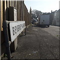
Ensbury Park: Beverley Gardens
The parked van allows us only a glimpse along this snaking no-through road, but that glimpse tells us that it consists of desirable detached houses and is not a modern cul-de-sac like many of the infill developments in the area.
The sign also tells us that the road isn't modern: it looks like an ordinary 1980s sign mounted on tubular steel (such as the one at
Image), but careful scrutiny will tell us that the lettering and black border is embossed in the metalwork and not put on adhesively like the more modern variety. This makes it one of the older, perhaps 1960s, nameplates.
This is photo no.39 of a series of 451 in my coronavirus lockdown walking project:
See https://www.geograph.org.uk/article/My-2020-Coronavirus-Lockdown-walking-project for the complete set of photos.
Image: © Chris Downer
Taken: 11 Apr 2020
0.04 miles
2
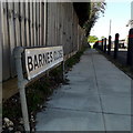
Ensbury Park: Barnes Close
This is a small infill cul-de-sac dating from the late 1970s or early 80s; the housing cannot be seen from here because it is around a left turn behind the gardens of Barnes Crescent.
The posts, allowing safer pedestrian access, were put in between 2009 and 2012 according to Google Street View.
The sign is probably the original one, typical 70s/80s Bournemouth nameplate mounted on tubular steel which protrudes at each end.
This is photo no.27 of a series of 451 in my coronavirus lockdown walking project:
See https://www.geograph.org.uk/article/My-2020-Coronavirus-Lockdown-walking-project for the complete set of photos.
Image: © Chris Downer
Taken: 13 Apr 2020
0.06 miles
3
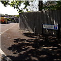
Northbourne: Doveshill Gardens
The position of the sign, towards the middle rather than the point of the triangular pavement entrance, leaves us with just a glimpse of the bungalows that are to be found down there.
The road sign is a standard one from around 2000-2006, perhaps a little earlier, featuring the borough coat of arms. A no-through-road sign is incorporated into the nameplate, whereas there would originally have been a standalone one on the vacant post to the left (see
Image for an example of such arrangement).
This is photo no.111 of a series of 453 in my coronavirus lockdown walking project:
See https://www.geograph.org.uk/article/My-2020-Coronavirus-Lockdown-walking-project for the complete set of photos.
Image: © Chris Downer
Taken: 19 Apr 2020
0.07 miles
4
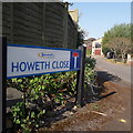
Ensbury Park: Howeth Close
A short cul-de-sac of maybe 1970s housing off the major side-road, Howeth Road.
The sign is a modern one, from 2010-15 when this more modern, abstract emblem rather than the traditional town coat of arms as the working logo of the council.
This is photo no.206 of a series of 453 in my coronavirus lockdown walking project:
See https://www.geograph.org.uk/article/My-2020-Coronavirus-Lockdown-walking-project for the complete set of photos.
Image: © Chris Downer
Taken: 11 Apr 2020
0.08 miles
5
East Howe: footpath U40 from Heather Road
This public footpath leads from Heather Road to Green Lane. It is a narrow, grass/earth track which is quite overgrown in places. Perhaps it is little used because a much better, tarmacked path runs parallel 100 yards or so to the south.
See
Image for the next view along the path.
Image: © Chris Downer
Taken: 3 Jul 2016
0.11 miles
6
East Howe: footpath U40 approaches Heather Road
This public footpath leads from Green Lane to Heather Road. It is a narrow, grass/earth track which is quite overgrown in places. Perhaps it is little used because a much better, tarmacked path runs parallel 100 yards or so to the south.
See
Image for the next view along the path ahead, and
Image for the next view behind us.
Image: © Chris Downer
Taken: 3 Jul 2016
0.11 miles
7
East Howe, Doveshill Park
Park home site on Barnes Road. http://www.bournemouthparkhomes.co.uk/doves-hill/
Image: © Mike Faherty
Taken: 1 Mar 2010
0.11 miles
8
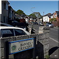
Ensbury Park: Barnes Crescent
In an area of detached houses, Barnes Crescent is an angular, trapezium shaped crescent off Barnes Road. This is its western end.
The sign is a Bournemouth Borough one with the borough coat of arms, dating from around 2000-2006, possibly a little earlier.
This is photo no.28 of a series of 451 in my coronavirus lockdown walking project:
See https://www.geograph.org.uk/article/My-2020-Coronavirus-Lockdown-walking-project for the complete set of photos.
Image: © Chris Downer
Taken: 13 Apr 2020
0.11 miles
9
Ensbury Park: postbox № BH10 289, Howeth Road
A George V-reign postbox on the corner of Howeth and Barnes Roads. There was also a phone box alongside until a few years ago.
Image: © Chris Downer
Taken: 25 Jun 2008
0.12 miles
10
East Howe: overgrowing undergrowth on footpath U40
This public footpath leads from Green Lane (behind us) to Heather Road. It is a narrow, grass/earth track which is quite overgrown in places. Perhaps it is little used because a much better, tarmacked path runs parallel 100 yards or so to the south.
See
Image for the next view along the path ahead, and
Image for the next view behind us.
Image: © Chris Downer
Taken: 3 Jul 2016
0.12 miles


