IMAGES TAKEN NEAR TO
Boundary Road, BOURNEMOUTH, BH10 4HH
Introduction
This page details the photographs taken nearby to Boundary Road, BH10 4HH by members of the Geograph project.
The Geograph project started in 2005 with the aim of publishing, organising and preserving representative images for every square kilometre of Great Britain, Ireland and the Isle of Man.

There are currently over 7.5m images from over14,400 individuals and you can help contribute to the project by visiting https://www.geograph.org.uk
Image Map
Images are licensed for reuse under creativecommons.org/licenses/by-sa/2.0
Notes
- Clicking on the map will re-center to the selected point.
- The higher the marker number, the further away the image location is from the centre of the postcode.
Image Listing (134 Images Found)
Images are licensed for reuse under creativecommons.org/licenses/by-sa/2.0
Image
Details
Distance
1
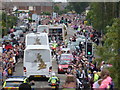
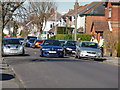
Ensbury Park: the Olympic torch relay from behind
Looking along Boundary Road as the Olympic torch relay has just passed below us. The torch bearers are this side of the third vehicle along, which has official photographers facing out the back.
Image: © Chris Downer
Taken: 13 Jul 2012
0.03 miles
2
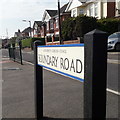
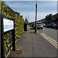
Ensbury Park: Boundary Road
Boundary Road was, as its name suggests, a boundary and it was quite a major one: it was the boundary between Hampshire and Dorset until 1931, when the area to the west of here was transferred to Bournemouth and thus to Hampshire. (The whole of Bournemouth would then transfer from Hampshire to Dorset 70 years later.)
While it has diminished in the importance of the boundary, it has gained importance as a route. Until quite recently it was a gravel road, when the A347 went along Wimborne Road through Moordown and Winton. But in the mid-1980s the A347 was rerouted to Redhill Avenue, through Redhill Common, and along here, so it is now a busy main road carrying much suburban and regional traffic to and from Bournemouth town.
We view it here at the traffic-light junction with Victoria Avenue; the houses have their own parallel service road which comes past the junction.
The sign, announcing the street name to traffic arriving from Victoria Avenue, is a modern one, erected around 2017, by which time the council had replaced the coloured logo, which had been prone to fading after a while, to simple wording BOURNEMOUTH BOROUGH COUNCIL in smaller type.
This is photo no.44 of a series of 453 in my coronavirus lockdown walking project:
See https://www.geograph.org.uk/article/My-2020-Coronavirus-Lockdown-walking-project for the complete set of photos.
Image: © Chris Downer
Taken: 10 Apr 2020
0.03 miles
3
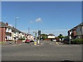
Ensbury Park: the end of Victoria Avenue and Victoria Park Road
The houses on the left are the odd numbers of Victoria Park Road, ending with number 97 just out of shot, while those on the right are evens of Victoria Avenue, ending with number 86 on the far right. The reason is that Victoria Avenue swings round to the right while Victoria Park Road runs straight ahead. The road signs bottom-left and bottom-right reflect this oddity.
Image: © Chris Downer
Taken: 22 Jun 2008
0.05 miles
4
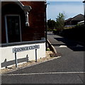
Ensbury Park: George Close
A very modern infill cul-de-sac off Beswick Avenue, George Close contains some university student accommodation. Many original houses in this neck of the woods have also become student houses; it is an ideal location a 15-minute or so walk to the main campus of Bournemouth University and the Arts University.
The road sign is a nonstandard one which has, therefore, presumably been installed by the developers rather than the council.
This is photo no.157 of a series of 453 in my coronavirus lockdown walking project:
See https://www.geograph.org.uk/article/My-2020-Coronavirus-Lockdown-walking-project for the complete set of photos.
Image: © Chris Downer
Taken: 19 Apr 2020
0.06 miles
5
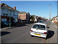
Bournemouth : Beswick Avenue
A car driving along Beswich Avenue, and some police officers are having a chat with a resident.
Image: © Lewis Clarke
Taken: 8 Mar 2010
0.06 miles
6
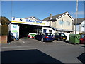
Bournemouth : Stanfield Garage, Gorsecliff Road
A garage on Gorsecliff Road where mechanics try and fix cars and such.
Image: © Lewis Clarke
Taken: 8 Mar 2010
0.07 miles
7
Bournemouth : Beswick Avenue
Beswick Avenue which leads towards Columbia Road.
Image: © Lewis Clarke
Taken: 8 Mar 2010
0.07 miles
8
Bournemouth : Beswick Avenue
Beswick Avenue is a residential street
Image: © Lewis Clarke
Taken: 25 May 2008
0.07 miles
9
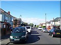
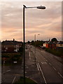
Ensbury Park: Gorsecliff Road
A two-segment road of early 20th century detached houses, off what was then the minor Boundary Road. Since the early 1980s, when Boundary Road became the main A347 into Bournemouth, Gorsecliff Road has become a busy cut-through to miss the Ensbury Park Gyratory, as it is the first through road turn-off northbound, after Glenmoor school grounds.
As these houses were built before off-road parking was a consideration, it can get rather snarled up where someone queuing to pull out does so between parked cars, blocking the way for oncoming traffic.
It is easy to blame it on bravado or impatience – and it often is – but there are times when one just doesn't realise until it is too late to do anything about it.
The sign is a modern one, from 2010-15 when this more modern, abstract emblem rather than the traditional town coat of arms as the working logo of the council.
This is photo no.168 of a series of 453 in my coronavirus lockdown walking project:
See https://www.geograph.org.uk/article/My-2020-Coronavirus-Lockdown-walking-project for the complete set of photos.
Image: © Chris Downer
Taken: 19 Apr 2020
0.07 miles
10
Ensbury Park: pigeon on lamppost in Boundary Road
Looking north along Boundary Road – the boundary between Bournemouth and Poole (and thus, Hampshire and Dorset) until 1904 when the Kinson area to the west was transferred to Bournemouth. In 1974 the whole of Bournemouth became part of Dorset, meaning that the land to the west of here has been part of Poole (Dorset), then Bournemouth (Hants.), and finally Bournemouth (Dorset).
Image: © Chris Downer
Taken: 29 Jul 2009
0.08 miles