IMAGES TAKEN NEAR TO
Constitution Hill, WELLS, BA5 3NS
Introduction
This page details the photographs taken nearby to Constitution Hill, BA5 3NS by members of the Geograph project.
The Geograph project started in 2005 with the aim of publishing, organising and preserving representative images for every square kilometre of Great Britain, Ireland and the Isle of Man.

There are currently over 7.5m images from over14,400 individuals and you can help contribute to the project by visiting https://www.geograph.org.uk
Image Map (Loading...)


Getting Data...Please wait
Leaflet Map data © OpenStreetMap
Images are licensed for reuse under creativecommons.org/licenses/by-sa/2.0
Notes
- Clicking on the map will re-center to the selected point.
- The higher the marker number, the further away the image location is from the centre of the postcode.
Image Listing (18 Images Found)
Images are licensed for reuse under creativecommons.org/licenses/by-sa/2.0
Image
Details
Distance
1
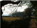
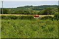
Old coach road
Late evening sunshine in March 2006 on a 17th century coaching road. The structure in the background is a WW2 type 29 pillbox on "defence line green", a defence line for Bristol, which fortunately was never needed.
Image: © brian
Taken: 18 Mar 2006
0.05 miles
2
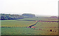
Somerset countryside SW of Wells, 1987
View SW from the B3139 just east of Wells. The weather was not too good, but it may possibly be Glastonbury Tor on the left horizon.
Image: © Ben Brooksbank
Taken: 5 May 1987
0.08 miles
3
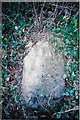
Old Milestone, B3139, Constitution Hill, between Dulcote & Wells
The milestone is set into a high bank on the south side of the road. Parish of St Cuthbert Out (Mendip district). Stone post (plate lost), Wells iron plate design, erected by the Wells turnpike trust in the 19th century.
Inscription once read:-
WELLS / I
Milestone Society National ID: SO_SMWL04
Image: © Janet Dowding
Taken: 9 Feb 2008
0.10 miles
4

Path to Wells, with the cathedral visible across fields
Image: © David Martin
Taken: 1 Jun 2019
0.10 miles
5
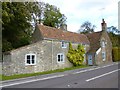
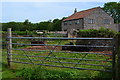
Old Toll House, Wells
Toll House in the parish of Wells, Tor Hill Gate Cottage, Tor Hill.
Grade II listed.
List Entry Number: 1383181 https://historicengland.org.uk/listing/the-list/list-entry/1383181
Surveyed
Milestone Society National ID: SO.WEL03
Image: © Alan Rosevear
Taken: 30 Oct 2013
0.11 miles
8
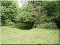
Tor Hill
This depression in the ground is the result of an old, small limestone quarry. A much larger quarry (Torhill - also disused now) lies to the south. The vegetation has now totally regrown leaving an interesting feature in the landscape.
Image: © Sharon Loxton
Taken: 4 Jun 2006
0.13 miles
10
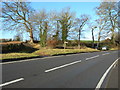
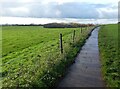
Footpath Crossing at Constitution Hill, near Dulcote
There is a small parking area here, and the path towards the left of the picture goes into Wells.
Image: © Danny P Robinson
Taken: 29 Dec 2007
0.15 miles