IMAGES TAKEN NEAR TO
Priddy, WELLS, BA5 3AX
Introduction
This page details the photographs taken nearby to BA5 3AX by members of the Geograph project.
The Geograph project started in 2005 with the aim of publishing, organising and preserving representative images for every square kilometre of Great Britain, Ireland and the Isle of Man.

There are currently over 7.5m images from over14,400 individuals and you can help contribute to the project by visiting https://www.geograph.org.uk
Image Map
Images are licensed for reuse under creativecommons.org/licenses/by-sa/2.0
Notes
- Clicking on the map will re-center to the selected point.
- The higher the marker number, the further away the image location is from the centre of the postcode.
Image Listing (13 Images Found)
Images are licensed for reuse under creativecommons.org/licenses/by-sa/2.0
Image
Details
Distance
1
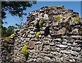
Ruin, Eastwater
The stonecrop wall-pepper (Sedum acre), adorns a gable end of a ruined barn on East Water Lane.
Image: © Derek Harper
Taken: 17 Jun 2010
0.04 miles
2
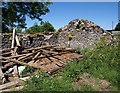
Ruined barn, Eastwater
A wider view of Image, with a collapsed roof. This is beside East Water Lane, a no through lane for traffic but which carries Restricted Byway WS 8/38 north to Nine Barrows Lane.
Image: © Derek Harper
Taken: 17 Jun 2010
0.04 miles
3
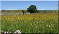
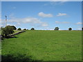
Meadow, Eastwater
A buttercup-filled meadow beside East Water Lane just north of the end of the public road and the start of byway WS 8/38. A drystone wall leads towards an oak.
Image: © Derek Harper
Taken: 17 Jun 2010
0.08 miles
4
Eastwater Lane path
This post seems to have been temporarily uprooted, although is pointing in the right direction.
Image: © Neil Owen
Taken: 13 Apr 2016
0.11 miles
6
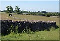
Wall by East Water Lane
A wandering dry stone wall between fields of grass north of Eastwater.
Image: © Derek Harper
Taken: 17 Jun 2010
0.19 miles
7
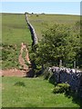
Dry stone wall, Eastwater
From WS 8/33, beside a stile across the wall. The valley leads immediately to Eastwater Cavern (right).
Image: © Derek Harper
Taken: 17 Jun 2010
0.20 miles
8
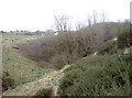
The slopes of Eastwater
The porous Limestone landscape of the Mendips leads to many a stream and sudden drop into a swallow hole. This is the gorse-lined slopes Eastwater, with a near-vertical wall at its end; at the lowest point of which is the Eastwater Cavern - Image
Image: © Neil Owen
Taken: 13 Apr 2016
0.23 miles
9
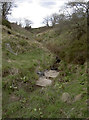
East Water
This little stream runs above ground for a relatively short distance before disappearing underground at Eastwater Cavern. Today the pile of old tyres and sheeting mark the actual place where it drops below ground level, although the recent heavy rains also leave evidence that it did get to the cave entrance.
Image: © Neil Owen
Taken: 13 Apr 2016
0.24 miles
10
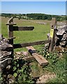
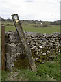
Stile by East Water Lane
Something was in a hurry to get onto footpath WS 8/10 which leaves the byway through the remains of this stile.
Image: © Derek Harper
Taken: 17 Jun 2010
0.24 miles