IMAGES TAKEN NEAR TO
Somerleaze Close, WELLS, BA5 1UD
Introduction
This page details the photographs taken nearby to Somerleaze Close, BA5 1UD by members of the Geograph project.
The Geograph project started in 2005 with the aim of publishing, organising and preserving representative images for every square kilometre of Great Britain, Ireland and the Isle of Man.

There are currently over 7.5m images from over14,400 individuals and you can help contribute to the project by visiting https://www.geograph.org.uk
Image Map (Loading...)


Getting Data...Please wait
Leaflet Map data © OpenStreetMap
Images are licensed for reuse under creativecommons.org/licenses/by-sa/2.0
Notes
- Clicking on the map will re-center to the selected point.
- The higher the marker number, the further away the image location is from the centre of the postcode.
Image Listing (15 Images Found)
Images are licensed for reuse under creativecommons.org/licenses/by-sa/2.0
Image
Details
Distance
1
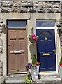
A different set of numbers
Look closely and you will notice the numbers carved into the lintels are 5 and 6 - not the ones on the actual doors. Clearly the original numbering of Victoria Terrace (in Burcott Road) of 1888 has been changed. The area dates from around the turn of the nineteenth century when there was an isolation hospital just along the road.
Image: © Neil Owen
Taken: 24 Jun 2014
0.17 miles
2
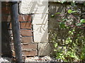
Benchmark in Burcott Road
A cutmark, as described in the Benchmark Database: http://www.bench-marks.org.uk/bm58659 , on the side of a house in Burcott Road. See Image] for a wider view of this renumbered road.
Image: © Neil Owen
Taken: 24 Jun 2014
0.18 miles
3
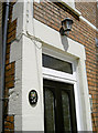
A change of address
This is number 24 Burcott Road, but look carefully and you will note the number 1 on the door lintel. Clearly there has been a change of numbering at some point, as can be seen on other houses in the area - see Image A benchmark can also be found on this corner of the alleyway - see Image
Image: © Neil Owen
Taken: 24 Jun 2014
0.18 miles
4
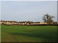
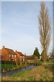
The western edge of Wells
A view east towards the houses on the estate on the westernmost edge of Wells. Taken from the footpath which runs around the sewage works.
Image: © Sharon Loxton
Taken: 26 Jan 2008
0.19 miles
5
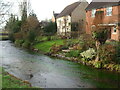
Keward Brook
The Keward Brook runs through Wells and then heads off west to join the River Sheppey and eventually flow across the Somerset Levels.
Image: © Sharon Loxton
Taken: 26 Jan 2008
0.20 miles
6
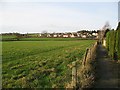
Bubwith Walk
This walkway is at the back of the houses in Martin's Close. I lived in one of the houses throughout my school years, and used to play in the field on the left. The estate in the distance was not there at that time.
Image: © Sharon Loxton
Taken: 26 Jan 2008
0.21 miles
7

Balch Road
This modern road is named after Herbert Balch. The street sign states: 'Founder and first curator of Wells & Mendip Museum during the late 19th century. Balch was a keen local naturalist, caver and geologist. He was created an honourary freeman of the City of Wells in 1994.'
Image: © Neil Owen
Taken: 24 Jun 2014
0.23 miles
8
Keward Brook
The modern houses are a very recent addition. In the pre-war period the brook ran to Keward House and Mill, of which the latter is now replaced by a small industrial park. However, in the more distant past this spot held a much more serious significance. See Image
Image: © Neil Owen
Taken: 14 Dec 2022
0.23 miles
9
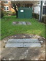
Jocelyn Drive sewage pumping station
A small unit with underground chambers, right beside the Keward Brook. In the last century there was a much bigger seage treatment works a little to the north of the brook, but it has been replaced with modern housing.
Image: © Neil Owen
Taken: 14 Dec 2022
0.23 miles
10

'The Gatehouse'
Formerly a toll house on the Coxley road, this house bears a benchmark on the furthest corner. See Image
Image: © Neil Owen
Taken: 14 Dec 2022
0.23 miles