IMAGES TAKEN NEAR TO
The Green, RADSTOCK, BA3 5LY
Introduction
This page details the photographs taken nearby to The Green, BA3 5LY by members of the Geograph project.
The Geograph project started in 2005 with the aim of publishing, organising and preserving representative images for every square kilometre of Great Britain, Ireland and the Isle of Man.

There are currently over 7.5m images from over14,400 individuals and you can help contribute to the project by visiting https://www.geograph.org.uk
Image Map
Images are licensed for reuse under creativecommons.org/licenses/by-sa/2.0
Notes
- Clicking on the map will re-center to the selected point.
- The higher the marker number, the further away the image location is from the centre of the postcode.
Image Listing (33 Images Found)
Images are licensed for reuse under creativecommons.org/licenses/by-sa/2.0
Image
Details
Distance
1
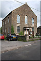
Coleford: Wesleyan Methodist chapel
Built in 1865, some time after the abandonment of the Dorset & Somerset Canal, which ran in cutting to the left.
Image: © Martin Bodman
Taken: 8 Aug 2008
0.10 miles
2
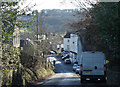
2011 : Church Street, Coleford near the top of the hill
In the 18th and 19th centuries Coleford was a mining village. Now its main industries are farming and quarrying of Mendip limestone.
"Apart from agriculture, the main industry in recent history (between 1700 - 1900), was coal mining. Originally a cottage industry, demand grew with the industrial revolution. The main pits in the area were Coalbarton pit, which closed in 1869 following a firedamp explosion which killed 9 miners, and Newbury and Mackintosh pits. Mackintosh opened in 1867 and closed in 1919, due to a failure of the pit cage rope. Suitable rope was in short supply because of the First World War. It was not possible to bring up the pit ponies without the cage working, so they had to be killed down in the mine. Newbury pit closed around 1927. Other pits in the area were at Vobster and Mells."
The above was copied from: http://colefordsomerset.org/History/index.html
Image: © Maurice Pullin
Taken: 8 Feb 2011
0.12 miles
3

The Mells Stream at Coleford
Busily flowing down towards Frome.
Image: © Neil Owen
Taken: 4 Aug 2021
0.13 miles
4
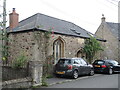
The old Sunday School
Coleford school, built 1843, next to the Wesleyan Methodist church. It is now a private residence.
Image: © Neil Owen
Taken: 4 Aug 2021
0.13 miles
5
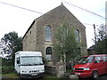
Coleford Wesleyan Methodist chapel
Founded in 1865.
Image: © Neil Owen
Taken: 4 Aug 2021
0.13 miles
6
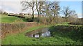
Former Dorset and Somerset Canal
Looking East below Coleford.
Image: © Dr Duncan Pepper
Taken: 15 Jan 2016
0.13 miles
7
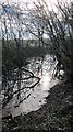
Remains of the Somerset Coal Canal looking west below Coleford
Image: © Dr Duncan Pepper
Taken: 15 Jan 2016
0.14 miles
8

The Kings Head, Coleford
Opened in the seventeenth century and retaining many period features, the inn carries on offering a warm welcome. A sign relates that it was badly damaged by a fire but rebuilt in 1830.
Image: © Neil Owen
Taken: 4 Aug 2021
0.15 miles

10
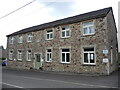
Coleford village hall
The hall has a datestone of 1963, but it appears to have been a welfare institute before that - for at least a few decades.
Image: © Neil Owen
Taken: 4 Aug 2021
0.18 miles