IMAGES TAKEN NEAR TO
Albert Avenue, BATH, BA2 8JD
Introduction
This page details the photographs taken nearby to Albert Avenue, BA2 8JD by members of the Geograph project.
The Geograph project started in 2005 with the aim of publishing, organising and preserving representative images for every square kilometre of Great Britain, Ireland and the Isle of Man.

There are currently over 7.5m images from over14,400 individuals and you can help contribute to the project by visiting https://www.geograph.org.uk
Image Map
Images are licensed for reuse under creativecommons.org/licenses/by-sa/2.0
Notes
- Clicking on the map will re-center to the selected point.
- The higher the marker number, the further away the image location is from the centre of the postcode.
Image Listing (20 Images Found)
Images are licensed for reuse under creativecommons.org/licenses/by-sa/2.0
Image
Details
Distance
1
The miners' welfare recreation ground
Decorated with an appropriate relic. The ground used to have the Miners' Institute Hall just up the road but that has now gone, as has the old band-stand.
Image: © Neil Owen
Taken: 24 May 2022
0.06 miles
2
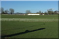
Recreation Ground, Peasedown St John
The Miners Welfare Recreation Ground, seen here from the Fosse Way / Bath Road.
Image: © Derek Harper
Taken: 24 Feb 2016
0.10 miles
3
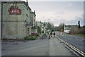
The Red Post Inn, Peasedown St John
The A367 no longer goes through Peasdown St John but has been made into a bypass
Image: © Dominic Dawn Harry and Jacob Paterson
Taken: 19 Feb 2006
0.10 miles
4
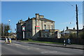
Red Post Inn, Peasedown St John
The pub, also shown in Image, is listed and described at https://www.historicengland.org.uk/listing/the-list/list-entry/1365679 . The pub dates from 1851, when it looked forward to nearly 150 years of the main road to Bath running past its doors along the Fosse Way; the A367 now bypasses the village and the pub. Also listed and visible on the right by the junction with Wellow Lane is the white-painted turnpike boundary marker with a pointed top dated 1827 https://www.historicengland.org.uk/listing/the-list/list-entry/1129504 .
Image: © Derek Harper
Taken: 24 Feb 2016
0.10 miles
5
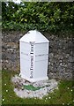
Old Boundary Marker by the former A367, Bath Road, Red Post, Peasedown St John
Parish Boundary Marker - Turnpike by the UC (was A367), in parish of Peasedown St John (Bath and North East Somerset District), Red Post Inn, Bath Road, junction with Wellow Lane, on verge in front of stone wall to right of pub.
Inscription reads:-
: WELLOW : : 1827 / BATH TURNPIKE TRUST (vertical) : : CAMERTON :
Grade II listed. List Entry Number: 1129504
https://historicengland.org.uk/listing/the-list/list-entry/1129504
Surveyed
Milestone Society National ID: SO_BARA05pb
Image: © Alan Rosevear
Taken: 24 Jun 2013
0.11 miles
6
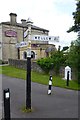
Old Direction Sign - Signpost by the former A367, Bath Road, Peasedown St John
Pyramid finial - 3 arms; Somerset SCC pyramid by the UC road (was A367), in parish of Peasedown St John (Bath And North East Somerset District), Red Post Inn, Bath Road, junction with Wellow Lane, on pavement to right of pub.
Surveyed
Milestone Society National ID: SO_ST6957.
Image: © Alan Rosevear
Taken: 24 Jun 2013
0.11 miles
7
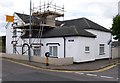
Tollhouse - Old Red Post Bakery, by Bath Road
In the parish of Peasedown St John (Bath And North East Somerset District), Old Red Post Bakery, Bath Road, at the junction with Whitebrook Lane.
Surveyed
Milestone Society National ID: AV.PEA
Image: © Alan Rosevear
Taken: 24 Jun 2013
0.12 miles
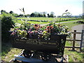
8
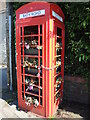
The blower replaced by flowers
An old phone box is now a community asset, having flowers instead. Note the chains to ensure they stay on display, although the glass has been removed.
Image: © Neil Owen
Taken: 24 May 2022
0.17 miles
9
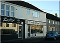
2008 : Shops at Peasedown St. John
Pop into the bakers for a cheese roll for elevenses, into the hairdressers for a shampoo & set (I should be so lucky!) then to Ken's Fish Bar for lunch. Life is good in Peasedown.
Image: © Maurice Pullin
Taken: 9 Feb 2008
0.17 miles
10

St John's hall
Next to the church is a metal-clad hall. It stands where the original church stood in the past.
Image: © Neil Owen
Taken: 24 May 2022
0.20 miles