IMAGES TAKEN NEAR TO
Ashgrove, BATH, BA2 8EG
Introduction
This page details the photographs taken nearby to Ashgrove, BA2 8EG by members of the Geograph project.
The Geograph project started in 2005 with the aim of publishing, organising and preserving representative images for every square kilometre of Great Britain, Ireland and the Isle of Man.

There are currently over 7.5m images from over14,400 individuals and you can help contribute to the project by visiting https://www.geograph.org.uk
Image Map
Images are licensed for reuse under creativecommons.org/licenses/by-sa/2.0
Notes
- Clicking on the map will re-center to the selected point.
- The higher the marker number, the further away the image location is from the centre of the postcode.
Image Listing (23 Images Found)
Images are licensed for reuse under creativecommons.org/licenses/by-sa/2.0
Image
Details
Distance
1
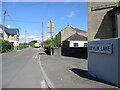
Eckweek Lane
An unusual name, and an older one than most of the surroundings. This was a lane in the nineteenth century that went to Eckweek Cottages and then Eckweek House - both are now lost to the modern housing. At that time Eckweek Road was merely a footpath, and the area was known as Ashgrove (perhaps after a cottage of that name, which has also gone).
Image: © Neil Owen
Taken: 24 May 2022
0.03 miles
2
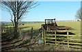
Sheep pasture, Peasedown St John
Sharing a field beside the Fosse Way (Ashgrove) with a tractor.
Image: © Derek Harper
Taken: 24 Feb 2016
0.03 miles
3
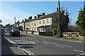
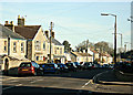
Houses on Ashgrove, Peasedown St John
A view along the Fosse Way, formerly the A367 through the centre of the village which is now bypassed.
Image: © Derek Harper
Taken: 24 Feb 2016
0.04 miles
4
Eckweek Lane, Peasedown St John
Permission exists for the erection of a bungalow on this site, just beyond the rather charmingly decaying little building on the right. At the end of the road is a T junction with the Fosse Way, here named Ashgrove.
Image: © Derek Harper
Taken: 24 Feb 2016
0.05 miles
5

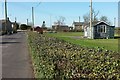
Fosse Way, Ashgrove
The former A376 leaves Peasedown St John, heading for the roundabout with the bypass.
Image: © Derek Harper
Taken: 24 Feb 2016
0.06 miles
6
2008 : The original Peasedown
This is the way things were before the dead hand of the planners took over.
Peasedown St. John was in existence for at least a thousand years without them, and existed very well.http://www.radstock4u.com/villagepages/peasedown/
Image: © Maurice Pullin
Taken: 9 Feb 2008
0.07 miles
7
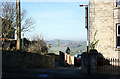
2008 : Between the houses at Peasedown
Looking north west toward Tunley.
Image: © Maurice Pullin
Taken: 9 Feb 2008
0.08 miles
8
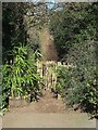
End of Eckweek Lane, Peasedown St John
The motorable lane may end along with the houses, but the line of it continues along bridleway BA 19/30 - alas for only 120 metres (see Image]).
Image: © Derek Harper
Taken: 24 Feb 2016
0.11 miles
9

Field above the Fosse Way
A wedge of a field between the truncated bridleway shown in Image] and the Fosse Way, the old main road through Peasedown St John.
Image: © Derek Harper
Taken: 24 Feb 2016
0.12 miles
10
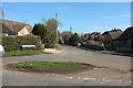
Junction, Peasedown St John
A grass circle that might pass muster as a triangle at the junction of Eckweek Lane with White Ox Mead Lane. The original course of both roads has been truncated by new road development.
Image: © Derek Harper
Taken: 24 Feb 2016
0.12 miles