IMAGES TAKEN NEAR TO
Monk Barton Close, YEOVIL, BA21 3UU
Introduction
This page details the photographs taken nearby to Monk Barton Close, BA21 3UU by members of the Geograph project.
The Geograph project started in 2005 with the aim of publishing, organising and preserving representative images for every square kilometre of Great Britain, Ireland and the Isle of Man.

There are currently over 7.5m images from over14,400 individuals and you can help contribute to the project by visiting https://www.geograph.org.uk
Image Map
Images are licensed for reuse under creativecommons.org/licenses/by-sa/2.0
Notes
- Clicking on the map will re-center to the selected point.
- The higher the marker number, the further away the image location is from the centre of the postcode.
Image Listing (20 Images Found)
Images are licensed for reuse under creativecommons.org/licenses/by-sa/2.0
Image
Details
Distance
2
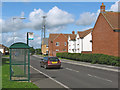
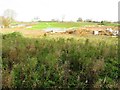
New estate at Yeovil
A pathway winds past houses on Biddlesden Road, part of a recent development northwest of Yeovil.
Image: © Derek Harper
Taken: 30 Aug 2007
0.08 miles
3

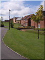
Abbey Manor Estate
This large bland amorphous housing estate built mainly during the 80's and 90's on the west side of yeovil dominates this quarter of the town. This is Merevale Way at its junction with Stourton Way.
Image: © Nigel Mykura
Taken: 11 Feb 2009
0.10 miles
6
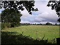
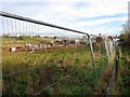
Field beside Thorne Lane
This is the view on the other side of Thorne Lane from Image Fields rise gently away towards Vagg Farm, which is in ST5318.
Image: © Derek Harper
Taken: 30 Aug 2007
0.14 miles
8
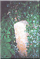
Old Boundary Marker by Thorne Lane, Brympton parish
Parish Boundary Marker by the UC road, in parish of Brympton (South Somerset District), Thorne Lane, West of junction with Western Ave, on verge surrounded by ivy and adjacent to large tree on North side of road.
Surveyed
Milestone Society National ID: SO_THOPPL01pb
Image: © Milestone Society
Taken: Unknown
0.14 miles
9

Path leading to Forde Park from Muchelney Way
Image: © Michael W Beales BEM
Taken: 2 Jun 2011
0.15 miles
