IMAGES TAKEN NEAR TO
Oriel Gardens, BATH, BA1 7AS
Introduction
This page details the photographs taken nearby to Oriel Gardens, BA1 7AS by members of the Geograph project.
The Geograph project started in 2005 with the aim of publishing, organising and preserving representative images for every square kilometre of Great Britain, Ireland and the Isle of Man.

There are currently over 7.5m images from over14,400 individuals and you can help contribute to the project by visiting https://www.geograph.org.uk
Image Map
Images are licensed for reuse under creativecommons.org/licenses/by-sa/2.0
Notes
- Clicking on the map will re-center to the selected point.
- The higher the marker number, the further away the image location is from the centre of the postcode.
Image Listing (38 Images Found)
Images are licensed for reuse under creativecommons.org/licenses/by-sa/2.0
Image
Details
Distance
1
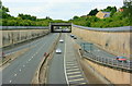
2008 : The A46 Gloucester Road
Seen from the A4/A46 junction at the western end of the Batheaston Bypass the A46 heads north toward the junction with the M4 then on to Cheltenham (not Gloucester).
The new Bailbrook Bridge is ahead and Lower Swainswick is on the other side of the retaining wall to the left.
Image: © Maurice Pullin
Taken: 4 Jul 2008
0.07 miles
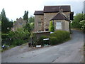
2
Bailbrook Bridge
Bridge over the A46
Image: © Stephen Bashford
Taken: 21 Nov 2005
0.08 miles
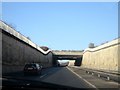
3
Overbridge over A46 near Lower Swainswick
First overbridge after the junction with the A4
Image: © John Firth
Taken: 4 Sep 2017
0.11 miles
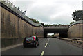
4

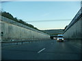
A46 tunnel, Lower Swainswick
Cut and cover construction, about 70 m long.
Image: © Robin Webster
Taken: 13 Nov 2022
0.12 miles
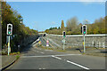
5
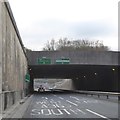
A46 underpass at Lower Swainswick
Approaching the junction with the A4
Image: © David Smith
Taken: 26 Nov 2016
0.14 miles
6
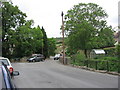
Lower Swainswick
Lower Swainswick is now on the edge of Bath, while Upper Swainswick remains isolated. This is the junction of Valley View Road, Deadmill Lane, Ferndale Road and St. Saviour's Road, taken from just outside the Bladud's Head pub.
Image: © HelenK
Taken: 21 May 2011
0.15 miles
7
The Lam Brook in Larkhall
Running down from the hills, the brook runs alongside St Saviour's Road and separates the road from the many houses lining it.
Image: © Neil Owen
Taken: 8 Jun 2020
0.15 miles
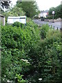
9
Deadmill Lane
A rather ominous name but the old mill used to grind corn.
Image: © Neil Owen
Taken: 8 Jun 2020
0.16 miles
10
Bath : Batheaston Swainswick Bypass
A road leading into Bath and out to the rest of North Somerset
Image: © Lewis Clarke
Taken: 22 Oct 2008
0.16 miles