IMAGES TAKEN NEAR TO
West Knoyle, WARMINSTER, BA12 6AL
Introduction
This page details the photographs taken nearby to BA12 6AL by members of the Geograph project.
The Geograph project started in 2005 with the aim of publishing, organising and preserving representative images for every square kilometre of Great Britain, Ireland and the Isle of Man.

There are currently over 7.5m images from over14,400 individuals and you can help contribute to the project by visiting https://www.geograph.org.uk
Image Map
Images are licensed for reuse under creativecommons.org/licenses/by-sa/2.0
Notes
- Clicking on the map will re-center to the selected point.
- The higher the marker number, the further away the image location is from the centre of the postcode.
Image Listing (21 Images Found)
Images are licensed for reuse under creativecommons.org/licenses/by-sa/2.0
Image
Details
Distance
1
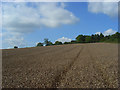
Wheat, West Knoyle
Were it not for the wet summer of 2008, this field would have been harvested weeks ago. The middle of September brought some relief for farmers and this crop, I dare say, will have now been gathered in. The grain will have had to been dried.
Image: © Andrew Smith
Taken: 13 Sep 2008
0.07 miles
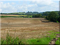
2
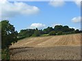
Farmland, West Knoyle
The trees screen West Hill Farm from view. The field has been partially harvested with wheat still standing in the foreground.
Image: © Andrew Smith
Taken: 13 Sep 2008
0.07 miles
3
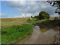
Bridleway, West Knoyle
The path connects West Hill Farm and the A303. Wet weather had led to it being very muddy, exacerbated by farm vehicles accessing fields.
Image: © Andrew Smith
Taken: 13 Sep 2008
0.10 miles
4
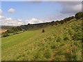
Downland, West Knoyle
A relatively small amount of foreground is within ST8432. The A303 is below, climbing Chaddenwick Hill.
Image: © Andrew Smith
Taken: 13 Sep 2008
0.13 miles
5
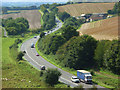
The A303, West Knoyle
Looking down from the access land to the south of the road on Chaddenwick Hill. Here it is a single carriageway road with an overtaking lane provided for traffic travelling uphill. Pitching Piece Farm is on the right with a turning for West Knoyle on the left.
Image: © Andrew Smith
Taken: 13 Sep 2008
0.16 miles
6
Farmland, West Knoyle
A view over partially harvested wheat from the bridleway at West Hill Farm.
Image: © Andrew Smith
Taken: 13 Sep 2008
0.16 miles
8
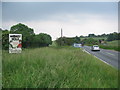
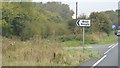
Junction for West Knoyle
A view looking to the southwest along the A303 towards the junction with the lane to West Knoyle. The rooftop of Pitching Piece Barn can be seen on the right.
Image: © Phil Williams
Taken: 10 Jun 2007
0.17 miles
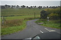
10
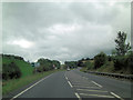
A303 approaches junction with The Cleeve
Image: © Stuart Logan
Taken: 4 Oct 2013
0.18 miles