IMAGES TAKEN NEAR TO
Leam Crescent, SOLIHULL, B92 8PB
Introduction
This page details the photographs taken nearby to Leam Crescent, B92 8PB by members of the Geograph project.
The Geograph project started in 2005 with the aim of publishing, organising and preserving representative images for every square kilometre of Great Britain, Ireland and the Isle of Man.

There are currently over 7.5m images from over14,400 individuals and you can help contribute to the project by visiting https://www.geograph.org.uk
Image Map
Images are licensed for reuse under creativecommons.org/licenses/by-sa/2.0
Notes
- Clicking on the map will re-center to the selected point.
- The higher the marker number, the further away the image location is from the centre of the postcode.
Image Listing (26 Images Found)
Images are licensed for reuse under creativecommons.org/licenses/by-sa/2.0
Image
Details
Distance
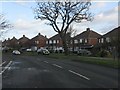
1

The Olton Tavern
A relatively modern town pub at the roundabout on Hobs Moat Road.
Image: © Richard Law
Taken: 31 Oct 2014
0.09 miles

3
Traffic island at the north end of B425 Lode Lane, Olton
The B425 continues north as Hobs Moat Road, to join the A45 Coventry Road. To the left is Castle Lane; to the right is Old Lode Lane.
Image: © Robin Stott
Taken: 14 Aug 2014
0.12 miles
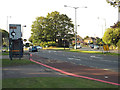
4

Roundabout on Hob's Moat Road
At the junction of Lode Lane, Hob's Moat Road and Old Lode Lane. The pedestrian crossing is clearly a recent innovation here.
Image: © Richard Law
Taken: 31 Oct 2014
0.12 miles


7
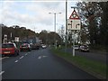
Lode Lane approaching the roundabout northbound
Image: © Peter Whatley
Taken: 7 Dec 2011
0.13 miles
8
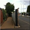
Public footpath, Lode Lane, Solihull
The path runs from Lode Lane to Tanhouse Farm Road and Elmdon Park. It skirts the fenced-off northern side of the Jaguar Land Rover site, one entrance to which can be seen to the right of the fence post. Fenced-off suburban gardens hem the path in on the other side, too. The OS Six Inch 1888-1913 map shows a path running from Lode Lane to the school in Elmdon Park near Elmdon Hall https://maps.nls.uk/geo/explore/side-by-side/#zoom=16&lat=52.44531&lon=-1.76364&layers=6&right=osm . The first section of the modern path follows this one, but it then turns to the left and follows long-lost field boundaries.
Image: © A J Paxton
Taken: 29 Aug 2022
0.13 miles
9

Remodelling north gate of Land Rover works, Lode Lane, Olton
Entrances to the vast Land Rover works offer the only views into the site. It is bounded by high earth banks topped by 3m close-boarded fencing, The 1km shady public footpath, left, is disappointing in that respect though it leads to Elmdon Park.
Image: © Robin Stott
Taken: 14 Aug 2014
0.14 miles