IMAGES TAKEN NEAR TO
Hints, TAMWORTH, B78 3DP
Introduction
This page details the photographs taken nearby to B78 3DP by members of the Geograph project.
The Geograph project started in 2005 with the aim of publishing, organising and preserving representative images for every square kilometre of Great Britain, Ireland and the Isle of Man.

There are currently over 7.5m images from over14,400 individuals and you can help contribute to the project by visiting https://www.geograph.org.uk
Image Map
Images are licensed for reuse under creativecommons.org/licenses/by-sa/2.0
Notes
- Clicking on the map will re-center to the selected point.
- The higher the marker number, the further away the image location is from the centre of the postcode.
Image Listing (19 Images Found)
Images are licensed for reuse under creativecommons.org/licenses/by-sa/2.0
Image
Details
Distance
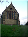
2
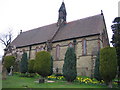
Hints Church
This small church is in a very quiet village. The surroundings are rural. The church is very near the Heart of England footpath.
Image: © Angella Streluk
Taken: 15 Apr 2006
0.06 miles
4
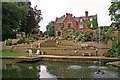
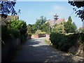
House and Garden, Hints
Taken during open garden event
Image: © Paul Buckingham
Taken: 29 May 2006
0.09 miles
5
St Bartholomews Church, Hints.
Hints in Staffordshire is a quaint rural backwater just off the A5 west of Tamworth
Image: © Sam Styles
Taken: 5 Mar 2005
0.10 miles
6
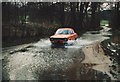
Black Brook at Hints ford being forded by a Ford
Black Brook flooding the road creating Hints ford, being forded by a Ford at Hints, Staffordshire.
Image: © ROWLAND TURNER
Taken: 10 Feb 1982
0.12 miles
7
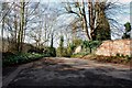
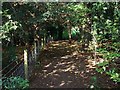
Driveway off School Lane, Hints
This drive has a large assortment of spring flowers just starting to show.
Image: © Mick Malpass
Taken: 1 Mar 2012
0.14 miles
8
Hints Ford
This ford is found on a byway called Rookery Lane in Hints.
http://www.youtube.com/watch?v=E9tIQSfCp7Y
http://youtu.be/SAILDA5X_sI
Image: © John Walton
Taken: 28 Dec 2013
0.15 miles
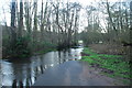
9

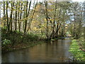
Black Brook, School Lane, Hints
This brook changes from Black Brook to Bourne Brook, but not sure where. There is a lovely crop of watercress just starting to show in this side channel.
Image: © Mick Malpass
Taken: 1 Mar 2012
0.15 miles
10
The Ford at Hints
This is the point where Rookery Lane crosses Black Brook and the river changes name to Bourne Brook. Nowadays,water only flows along the road after heavy rain. During drier spells, the river follows the original course under the road higher up.
Image: © Dave Toy
Taken: 26 Nov 2006
0.17 miles