IMAGES TAKEN NEAR TO
Doggetts Way, ST. ALBANS, AL1 2NF
Introduction
This page details the photographs taken nearby to Doggetts Way, AL1 2NF by members of the Geograph project.
The Geograph project started in 2005 with the aim of publishing, organising and preserving representative images for every square kilometre of Great Britain, Ireland and the Isle of Man.

There are currently over 7.5m images from over14,400 individuals and you can help contribute to the project by visiting https://www.geograph.org.uk
Image Map
Images are licensed for reuse under creativecommons.org/licenses/by-sa/2.0
Notes
- Clicking on the map will re-center to the selected point.
- The higher the marker number, the further away the image location is from the centre of the postcode.
Image Listing (54 Images Found)
Images are licensed for reuse under creativecommons.org/licenses/by-sa/2.0
Image
Details
Distance
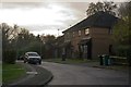
1
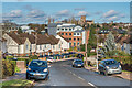
Doggets Way
Houses built in 1931-2, along with those in the adjacent Wilshere Avenue, by the Workman’s Housing Association to create what was then known as the Eywood estate. Beyond is the Centrium office development and in the background is St Albans Abbey.
Image: © Ian Capper
Taken: 13 Nov 2020
0.01 miles
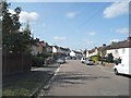
3
Doggetts Way, St Albans
Doggetts Way in a suburb of St Albans.
Image: © Malc McDonald
Taken: 26 Sep 2015
0.07 miles
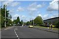
4
Griffiths Way, St Albans
Griffiths Way and the Abbey View retail park in St Albans.
Image: © Malc McDonald
Taken: 26 Sep 2015
0.10 miles
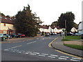
5
Mercer Row
1908s development off Wilshere Avenue. The road name commemorates Thomas Mercer Ltd, manufacturer of Chronographs and other instruments, who had a factory in nearby Eywood Road (now Griffiths Way) until the company closed in 1984.
Image: © Ian Capper
Taken: 3 Dec 2011
0.11 miles
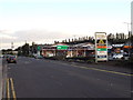
6
Griffiths Way, St Albans
The principal road of St Albans Retail Park. This was built on former gasworks and railway land.
Image: © Robin Webster
Taken: 14 May 2017
0.12 miles
7
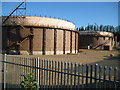
St Albans: Griffiths Way gasometers
From old Ordnance Survey maps it is evident that the site of the St Albans gas works was once much larger, stretching down to Stephen's Hill, and having its own dedicated railway siding, more or less on the site where Sainsbury's is now. These two holders are all that remains but they are large enough to warrant being individually represented on the current Ordnance Survey 1:50,000 scale mapping.
Image: © Nigel Cox
Taken: 29 May 2009
0.12 miles
8
Doggetts Way
A telephoto view of Doggetts Way in the St Stephens area of St Albans. On the right is St Bartholomew's RC Church. In the far distance an aeroplane can be seen having just taken off from Heathrow Airport
Image: © Ian Capper
Taken: 20 Apr 2013
0.12 miles
9
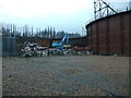
Demolition of St Albans Gasholders
The gasholders on the site of the former St Alban gasworks are now being demolished. See Image by Nigel Cox of the gasholders in 2009, having been out of use for some years and see Image for a glimpse of one holder in use in 1987.
Image: © John Webb
Taken: 5 Feb 2014
0.13 miles
10
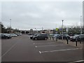
Sainsbury supermarket and car park, St Albans
Image: © David Smith
Taken: 29 Dec 2018
0.14 miles