IMAGES TAKEN NEAR TO
Cottonmill Lane, ST. ALBANS, AL1 2HE
Introduction
This page details the photographs taken nearby to Cottonmill Lane, AL1 2HE by members of the Geograph project.
The Geograph project started in 2005 with the aim of publishing, organising and preserving representative images for every square kilometre of Great Britain, Ireland and the Isle of Man.

There are currently over 7.5m images from over14,400 individuals and you can help contribute to the project by visiting https://www.geograph.org.uk
Image Map
Images are licensed for reuse under creativecommons.org/licenses/by-sa/2.0
Notes
- Clicking on the map will re-center to the selected point.
- The higher the marker number, the further away the image location is from the centre of the postcode.
Image Listing (32 Images Found)
Images are licensed for reuse under creativecommons.org/licenses/by-sa/2.0
Image
Details
Distance
1
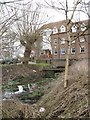
Sopwell Mill
Sopwell Mill seen through the trees. It is now an Office development. In the foreground is the old mill race, which carried water diverted from the River Ver.
Image: © Martin Addison
Taken: 9 Mar 2006
0.01 miles
2
River Ver
The River Ver where it is crossed by Cottonmill Lane.
Image: © Ian Capper
Taken: 20 Apr 2013
0.02 miles
3
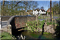
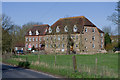
St Albans: New Barnes Mill
New Barnes Mill is a former corn mill, now converted to offices, on the River Ver where Cottonmill Lane crosses the river. Although the building is often referred to as Sopwell Mill, New Barnes Mill is its proper name. In fact the 1883 Ordnance Survey 6" to the mile map not only calls it Newbarns Mill, but the whole cluster of buildings around is described as New Barns with no mention of Sopwell at all. However, by the time that the 1899 Edition was published, the name Sopwell had materialized but the mill was by then called Newbarnes Mill.
Cottonmill Lane, seen on the right, may have been adequate for 19th century mill carts, but its narrow double right-angled bend around the mill presents a challenge to 21st century motorists.
Image: © Nigel Cox
Taken: 11 May 2009
0.04 miles
4
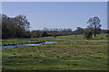
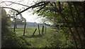
River Ver water meadows
An uncharacteristically high River Ver (a wet 2012 led to high levels of water in the chalk aquifer from which the river rises) crosses the water meadows below Cottonmill Lane.
Image: © Ian Capper
Taken: 20 Apr 2013
0.05 miles
5
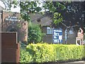
Christadelphians Church in Sopwell area
This church is on the opposite side of the road from St Aidans. but I have no clue as to activities
Image: © Jack Hill
Taken: 15 Aug 2005
0.05 miles
6
Sopwell Mill redevelopment.
The mill has been refurbished as offices but the turn to the right leads to a narrow bridge and a blind corner. Used by many commuters so rather tricky to negotiate.
Image: © Jack Hill
Taken: 10 Jul 2005
0.05 miles
7
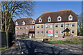
New Barnes Mill
Former flour mill, in use until the Second World War, now converted to offices and light industrial use. The original buildings date from the late 19th century.
Image: © Ian Capper
Taken: 20 Apr 2013
0.05 miles
8

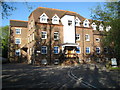
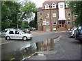
Sopwell House
Now a luxury hotel much used by professional football teams. Used to be the home of Prince Louis of Battenburg 1854-1921.
Image: © Bikeboy
Taken: 19 Jan 2014
0.05 miles
10
New Barnes Mill
Former flour mill, in use until the Second World War, now converted to offices and light industrial use. The original buildings date from the late 19th century.
Image: © Ian Capper
Taken: 20 Apr 2013
0.05 miles