IMAGES TAKEN NEAR TO
Sadleir Road, ST. ALBANS, AL1 2BW
Introduction
This page details the photographs taken nearby to Sadleir Road, AL1 2BW by members of the Geograph project.
The Geograph project started in 2005 with the aim of publishing, organising and preserving representative images for every square kilometre of Great Britain, Ireland and the Isle of Man.

There are currently over 7.5m images from over14,400 individuals and you can help contribute to the project by visiting https://www.geograph.org.uk
Image Map
Images are licensed for reuse under creativecommons.org/licenses/by-sa/2.0
Notes
- Clicking on the map will re-center to the selected point.
- The higher the marker number, the further away the image location is from the centre of the postcode.
Image Listing (40 Images Found)
Images are licensed for reuse under creativecommons.org/licenses/by-sa/2.0
Image
Details
Distance
1
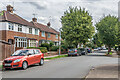
Mentmore Road
c.1930s housing in Mentmore Road, off Cottonmill Lane.
Image: © Ian Capper
Taken: 5 Aug 2021
0.06 miles
3
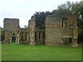
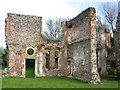
Ruined building, Sopwell
Remains of a Tudor mansion built on the site of Sopwell Nunnery. More at this http://www.stalbansmuseums.org.uk/Your-Visit/Sopwell-Nunnery
Image: © Jim Osley
Taken: 31 May 2013
0.09 miles
4
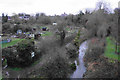
Nunnery Allotments and the River Ver
Looking down from Alban Way. St Albans Cathedral is seen in the distance.
Image: © Bill Boaden
Taken: 28 Feb 2020
0.10 miles
5
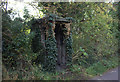
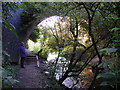
Railway shelter
The old St Albans to Hertford railway is now a pedestrian and cycle path but there are still relics to be seen. This one has almost been reclaimed by nature.
Image: © Robert Eva
Taken: 3 Nov 2016
0.10 miles
6
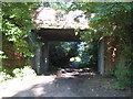
St Albans: Cottonmill Lane railway bridge
Leaving St Albans Abbey station, the former Hatfield and St Albans Railway left the current line to Watford Junction at a point just behind the photographer and this was the first crossing structure that it had to go under. The Great Northern Railway took over the line in 1883, but it was a very early casualty of British Railways' days being closed to passenger traffic in 1951. Freight services lingered on until 1964. The trackbed is now in use as a section of National Cycle Network Route 61 and is the start of the Alban Way, the dedicated footpath and cycleway between St Albans and Hatfield.
Those familiar with Cottonmill Lane will know that it makes a sudden and inexplicable sharp 90 degree turn just to the right of this photograph. Looking at old Ordnance Survey maps it is evident that the road formerly carried straight on to the existing railway, and the re-alignment seems to have occurred when the Berners Drive housing estate to the south was built.
Image: © Nigel Cox
Taken: 29 May 2009
0.11 miles
7
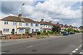
Cottonmill Lane
c.1930s housing in Cottonmill Lane, on the section between Leyland Avenue and Prospect Road. Although not developed until then, the route itself is much older, being the route from St Albans out to Sopwell from St Albans.
Image: © Ian Capper
Taken: 5 Aug 2021
0.11 miles
8
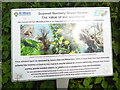
Sopwell Nunnery Information Board (1)
Located on the Abbey Line Trail in Sopwell Nunnery Green Space https://www.walkingenglishman.com/ldp/abbeylinetrail.html refers, this board has been erected by St Albans District Council and has the following wording on it.
Sopwell Nunnery Green Space:
The value of wet woodland.
Also known as Carr Woodland this is an important and rare wet woodland habitat
in Hertfordshire.
The images in the middle show the following:
Clockwise from the bottom left: Banded Demoiselle damselfly, Common Frog,
Riverside Willow, Lesser Celandine and Pollarded Willow
These woodland types are dominated by mature Alder and Willow trees. Some of
these trees have been historically pollarded (the branches cut back so they
re-grow to provide material for baskets and fencing, amongst other things) and
they provide excellent habitats for wildlife such as woodpeckers, bats and
invertebrates.
Image: © David Hillas
Taken: 30 May 2019
0.11 miles
9
The River Ver passing under a bridge of the Alban Way
The river and footpath both go under the bridge of the disused railway line between St Albans and Hatfield now the footpath/cycle track called The Alban Way
Image: © Peter Constable
Taken: 16 Jul 2000
0.12 miles
10
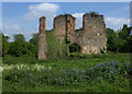
Ruined nunnery
The ruined nunnery at TL151064
Image: © Rob Hinkley
Taken: 10 Apr 2005
0.12 miles