IMAGES TAKEN NEAR TO
Leyland Avenue, ST. ALBANS, AL1 2BD
Introduction
This page details the photographs taken nearby to Leyland Avenue, AL1 2BD by members of the Geograph project.
The Geograph project started in 2005 with the aim of publishing, organising and preserving representative images for every square kilometre of Great Britain, Ireland and the Isle of Man.

There are currently over 7.5m images from over14,400 individuals and you can help contribute to the project by visiting https://www.geograph.org.uk
Image Map
Images are licensed for reuse under creativecommons.org/licenses/by-sa/2.0
Notes
- Clicking on the map will re-center to the selected point.
- The higher the marker number, the further away the image location is from the centre of the postcode.
Image Listing (49 Images Found)
Images are licensed for reuse under creativecommons.org/licenses/by-sa/2.0
Image
Details
Distance
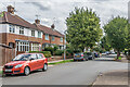
1
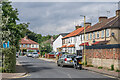
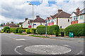
Leyland Avenue
c.1930s housing in Leyland Avenue, a cul-de-sac off Cottonmill Lane.
Image: © Ian Capper
Taken: 5 Aug 2021
0.02 miles
2
St Albans Abbey station - the view south
Image: © Peter Whatley
Taken: 11 Apr 2024
0.05 miles
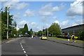
3
Cottonmill Lane
c.1930s housing in Cottonmill Lane, on the section between Leyland Avenue and Prospect Road. Although not developed until then, the route itself is much older, being the route from St Albans out to Sopwell from St Albans.
Image: © Ian Capper
Taken: 5 Aug 2021
0.07 miles
4
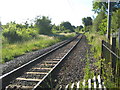
St Albans: The Abbey Flyer line
Looking towards Image it was about a 100 metres away in the distance that the former Great Northern Railway's line to Hatfield peeled off to the right. That line closed in 1964.
Image: © Nigel Cox
Taken: 29 May 2009
0.07 miles
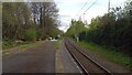
5
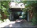
St Albans: Cottonmill Lane railway bridge
Leaving St Albans Abbey station, the former Hatfield and St Albans Railway left the current line to Watford Junction at a point just behind the photographer and this was the first crossing structure that it had to go under. The Great Northern Railway took over the line in 1883, but it was a very early casualty of British Railways' days being closed to passenger traffic in 1951. Freight services lingered on until 1964. The trackbed is now in use as a section of National Cycle Network Route 61 and is the start of the Alban Way, the dedicated footpath and cycleway between St Albans and Hatfield.
Those familiar with Cottonmill Lane will know that it makes a sudden and inexplicable sharp 90 degree turn just to the right of this photograph. Looking at old Ordnance Survey maps it is evident that the road formerly carried straight on to the existing railway, and the re-alignment seems to have occurred when the Berners Drive housing estate to the south was built.
Image: © Nigel Cox
Taken: 29 May 2009
0.08 miles
6
Cottonmill Lane
c.1930s housing in Cottonmill Lane, by its junction with Prospect Road. Although not developed until then, the route itself is much older, being the route from St Albans out to Sopwell from St Albans.
Image: © Ian Capper
Taken: 5 Aug 2021
0.09 miles
7
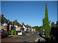
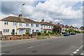
St Albans: Prospect Road
The houses at the eastern end of Prospect Road are mainly bay-fronted between-the-wars semis, but the totally vegetation-clad telegraph pole with its massed ranks of radiating cables was something different!
Image: © Nigel Cox
Taken: 29 May 2009
0.10 miles
8
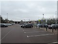
Sainsbury supermarket and car park, St Albans
Image: © David Smith
Taken: 29 Dec 2018
0.10 miles
9
Mentmore Road
c.1930s housing in Mentmore Road, off Cottonmill Lane.
Image: © Ian Capper
Taken: 5 Aug 2021
0.10 miles
10
Griffiths Way, St Albans
The principal road of St Albans Retail Park. This was built on former gasworks and railway land.
Image: © Robin Webster
Taken: 14 May 2017
0.11 miles