IMAGES TAKEN NEAR TO
Roberts Way, HATFIELD, AL10 9UT
Introduction
This page details the photographs taken nearby to Roberts Way, AL10 9UT by members of the Geograph project.
The Geograph project started in 2005 with the aim of publishing, organising and preserving representative images for every square kilometre of Great Britain, Ireland and the Isle of Man.

There are currently over 7.5m images from over14,400 individuals and you can help contribute to the project by visiting https://www.geograph.org.uk
Image Map
Images are licensed for reuse under creativecommons.org/licenses/by-sa/2.0
Notes
- Clicking on the map will re-center to the selected point.
- The higher the marker number, the further away the image location is from the centre of the postcode.
Image Listing (11 Images Found)
Images are licensed for reuse under creativecommons.org/licenses/by-sa/2.0
Image
Details
Distance
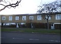
1
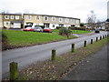
South Hatfield: Hazel Grove
Hazel Grove is the name of the road, but the road is named after an area of woodland to the north-west of the housing estate.
Image: © Nigel Cox
Taken: 5 Jan 2007
0.15 miles
3
Panorama from the top of the lift leading from the main campus to the student residences
Looking south-southwest.
Image: © Robert Lamb
Taken: 18 Oct 2014
0.19 miles
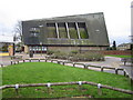
5
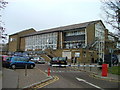
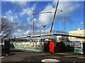
University of Hertfordshire
This building houses the main reception.
Image: © Robin Hall
Taken: 23 Nov 2005
0.21 miles
6
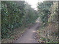
Alban Way. Old Nast Hyde Halt Station. Hatfield.
Alban Way is a cycle and footpath which runs along the route of the old Hatfield to St Albans railway.
The platform was the old Station, Nast Hyde Halt. It was opened in 1910 and closed in 1951. Photographed looking west from Ellenbrook Lane.
Image: © Barry Lawson
Taken: 24 Jan 2006
0.22 miles
7
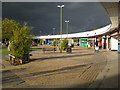
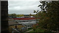
South Hatfield: High View shopping parade
The ominous dark sky portended the arrival of the unusual October snowstorm that left a couple of inches on the ground in this area later on in the day. In the meantime the High View shopping parade was basking in bright autumnal sunshine.
(From a Geograph point of view the intersection point of four grid squares, Image, Image, Image, and Image, falls just inside the shop with the bright green facings.)
Image: © Nigel Cox
Taken: 28 Oct 2008
0.23 miles
8
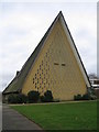
South Hatfield: The Church of St John (1)
This is the western façade of this prominent landmark church that is based on an A-frame type of construction and was completed in 1958 to the design of the architect Peter Bosanquet. The northern façade of the Church (the left hand edge in this image) is shown here Image
Image: © Nigel Cox
Taken: 5 Jan 2007
0.23 miles
9
South Hatfield: The Church of St John (2)
This is the northern façade of the church showing the varying height of the ridge of the roof, and the inset roof panels with glass at their tops. The Church was built in 1958 and the inset roof now has a substantial build-up of moss. The western façade of the Church (the right hand end in this image) is shown here Image
Image: © Nigel Cox
Taken: 5 Jan 2007
0.23 miles