IMAGES TAKEN NEAR TO
Selwyn Drive, HATFIELD, AL10 9NJ
Introduction
This page details the photographs taken nearby to Selwyn Drive, AL10 9NJ by members of the Geograph project.
The Geograph project started in 2005 with the aim of publishing, organising and preserving representative images for every square kilometre of Great Britain, Ireland and the Isle of Man.

There are currently over 7.5m images from over14,400 individuals and you can help contribute to the project by visiting https://www.geograph.org.uk
Image Map
Images are licensed for reuse under creativecommons.org/licenses/by-sa/2.0
Notes
- Clicking on the map will re-center to the selected point.
- The higher the marker number, the further away the image location is from the centre of the postcode.
Image Listing (56 Images Found)
Images are licensed for reuse under creativecommons.org/licenses/by-sa/2.0
Image
Details
Distance
2
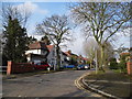
Ellenbrook Crescent
A semi circle of houses at the centre of the Ellenbrook neighbourhood on the western side of Hatfield.
In the foreground a small stream, presumably the Ellen Brook is culverted under the road. What looks like a water level monitor cabinet is by the railings.
Image: © Des Blenkinsopp
Taken: 25 Aug 2024
0.09 miles
6
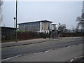
Part of the De Havilland Campus
The New De Havilland Campus part of the University of Hertfordshire. Built on the former Hatfield Airfield.
Image: © Rob Taylor
Taken: 23 Jan 2006
0.14 miles
9
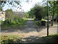
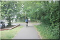
Hatfield: Route of the former Hatfield & St Albans Railway
The Hatfield & St Albans Railway opened their line through here, linking the two towns, in 1865. The railway was subsequently absorbed into the Great Northern Railway in 1883. Passenger services on the railway were an early casualty of the pre-Beeching era of British Railways, closing just 3 years into Nationalization in 1951. Freight traffic on the line lingered into the 1960s.
Today the route of the railway forms the Alban Way, or the Smallford Trail, and a section of National Cycle Network Route 61.
Image: © Nigel Cox
Taken: 19 Apr 2011
0.14 miles
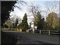
10
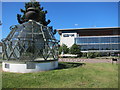
Lighthouse at the University of Hertfordshire
Prior to the advent of radar and radio navigation, airfields such as De Havillands at Hatfield were identified by a flashing beacon, this original light now adorns the campus of the University of Hertfordshire on the old Hatfield aerodrome.
Image: © Dr Duncan Pepper
Taken: 7 Jun 2015
0.14 miles