IMAGES TAKEN NEAR TO
Gordon Gardens, INVERURIE, AB51 4FJ
Introduction
This page details the photographs taken nearby to Gordon Gardens, AB51 4FJ by members of the Geograph project.
The Geograph project started in 2005 with the aim of publishing, organising and preserving representative images for every square kilometre of Great Britain, Ireland and the Isle of Man.

There are currently over 7.5m images from over14,400 individuals and you can help contribute to the project by visiting https://www.geograph.org.uk
Image Map
Images are licensed for reuse under creativecommons.org/licenses/by-sa/2.0
Notes
- Clicking on the map will re-center to the selected point.
- The higher the marker number, the further away the image location is from the centre of the postcode.
Image Listing (23 Images Found)
Images are licensed for reuse under creativecommons.org/licenses/by-sa/2.0
Image
Details
Distance
1
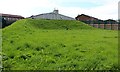
Water Reservoir off Burghmuir Drive
The enhanced security of the place (metal fence doubling the height of the old stone wall plus five strands of barbed wire atop) ensured my curiosity.
It appears that the housing estates were built much later and have been adapted to fit in around the fenced off area.
Image: © Bob Embleton
Taken: 17 Aug 2012
0.07 miles
2
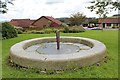
Pieces of a Puzzle
A 1995 artwork by Jeremy Cunningham.
Made from interlocking granite blocks with a metal upright at the centre.
The constellations of the Plough and Cassiopeia are inscribed on the base as pointers to the North Star.
Image: © Bob Embleton
Taken: 11 Aug 2011
0.10 miles
3
Suburban sculpture
A piece of public art entitled "Pieces of a Puzzle" by Jeremy Cunningham enlivens a token slice of green space in the 1990s suburban wasteland of Inverurie.
Image: © Bill Harrison
Taken: 30 Sep 2017
0.11 miles
4
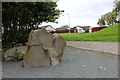
Site of the Brandsbutt Stone Circle
The circle has been marked out on the open grass patch in a housing estate.
The circle would have dated back to the third millennium BC, but all 12 (or possibly 13) stones have been removed and/or destroyed.
Image: © Bob Embleton
Taken: 11 Aug 2011
0.12 miles
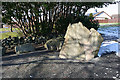
5
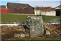
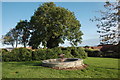
Douping Stone
This is one of the stones that made up the stone circle beside the Brandsbutt Stone. It and its fellow had been built into a field wall, but when the area was redeveloped as housing they were re-erected beide the Brandsbutt Stone. It is named on the 1:25,000 map as 'Douping Stone' but I have not found any explanation for this. https://canmore.org.uk/site/18882/brandsbutt for more information.
Image: © Anne Burgess
Taken: 25 Feb 2016
0.12 miles
6
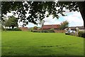
Brandsbutt Stone Circle
These two stones, plus the symbol stone a few metres away in the next square, are the remains of a stone circle. According to the 1:25,000 map the nearer one is called the Douping Stone, but I have not found any explanation of this. See https://canmore.org.uk/site/18882/brandsbutt for more information.
Image: © Anne Burgess
Taken: 25 Feb 2016
0.12 miles
7
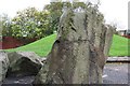
Brandsbutt Stone
This stone has been restored to some extent after its removal
from a dyke around the year 1900. It's a Pictish Symbol Stone. See http://www.aberdeenshire.gov.uk/archaeology/sites/pictish/bransbutt.asp
Image: © stephen samson
Taken: 20 Oct 2006
0.12 miles
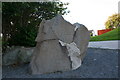
8
The Brandsbutt Pictish Stone
Broken and re-assembled.
It bears several standard symbols found on pictish stones including:
a V rod, a Z rod a crescent and a serpent.
In addition there is an ogham inscription: IRATADDOARENS
thought to mean Eddarrnon, possibly St. Ethernanus.
Image: © Bob Embleton
Taken: 11 Aug 2011
0.12 miles
9
Brandsbutt Stone
A stone of many pieces this Pictish stone was recovered from farmland as pieces and carefully reassembled.
Image: © Andrew Wood
Taken: 6 Oct 2008
0.13 miles
10
Brandsbutt Stone
The Brandsbutt stone bears Pictish carvings and an Ogham inscription. It was found broken into pieces in a field was but has been reassembled. See https://canmore.org.uk/site/18894/brandsbutt-inverurie-symbol-stone for more information.
Image: © Anne Burgess
Taken: 25 Feb 2016
0.13 miles