IMAGES TAKEN NEAR TO
Canal Road, INVERURIE, AB51 3UQ
Introduction
This page details the photographs taken nearby to Canal Road, AB51 3UQ by members of the Geograph project.
The Geograph project started in 2005 with the aim of publishing, organising and preserving representative images for every square kilometre of Great Britain, Ireland and the Isle of Man.

There are currently over 7.5m images from over14,400 individuals and you can help contribute to the project by visiting https://www.geograph.org.uk
Image Map
Images are licensed for reuse under creativecommons.org/licenses/by-sa/2.0
Notes
- Clicking on the map will re-center to the selected point.
- The higher the marker number, the further away the image location is from the centre of the postcode.
Image Listing (77 Images Found)
Images are licensed for reuse under creativecommons.org/licenses/by-sa/2.0
Image
Details
Distance
1
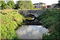
Bridge over the Lade
This is the original bridge that crossed the mill lade just before it joins the canal.
Image: © Anne Burgess
Taken: 29 Sep 2017
0.02 miles
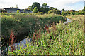
2
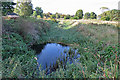
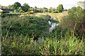
Canal Feeder
This rather overgrown waterway is the northern part of the canal, through which the canal was supplied with water from a sluice on the River Don. As you can see, it's deep and rather overgrown with vegetation. Not a good place for a swim, voluntarily or otherwise.
Image: © Anne Burgess
Taken: 29 Sep 2017
0.04 miles
3
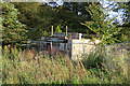
Sluice
This looks incontrovertibly like a sluice, and equally incontrovertibly disused. I believe that it controlled the flow of water from the lade into the barley and flour mills that stood nearby.
Image: © Anne Burgess
Taken: 29 Sep 2017
0.04 miles
4
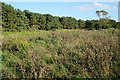
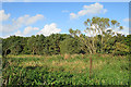
Rough Ground
This scene is deceptive because you can't see the channel of the river between here and the trees on Broom Inch in the background.
Image: © Anne Burgess
Taken: 29 Sep 2017
0.06 miles
5
Mill Lade
This is the lade that powered a large flour mill a couple of hundred metres south of here.
Image: © Anne Burgess
Taken: 29 Sep 2017
0.06 miles
6
Rough Ground
The satellite view seems to show pits and hollows on this piece of land between the lade and the River Don, but none of the maps gives any indication of what might have been here. I assumed it would be boggy and potentially dangerous and decided not to investigate more closely.
Image: © Anne Burgess
Taken: 29 Sep 2017
0.06 miles
7
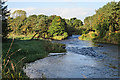
River Don
This is the point where the two channels of the river rejoin one another, one flowing on each side of Broom Inch
Image: © Anne Burgess
Taken: 29 Sep 2017
0.07 miles
8
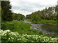
River Don, Port Elphinstone
In the distance, the joining of the two channels around Broom Inch.
Image: © Alan Murray-Rust
Taken: 22 May 2022
0.07 miles
9
Mill Lade
The canal feeder runs parallel to the mill lade, between the lade and the modern houses on the canal bank.
Image: © Anne Burgess
Taken: 29 Sep 2017
0.08 miles
10
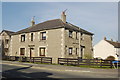
Maisonette, Elphinstone Road, Port Elphinstone
An unusual 1930s design for Inverurie.
Image: © Bill Harrison
Taken: 26 Mar 2012
0.10 miles