IMAGES TAKEN NEAR TO
Prospect Terrace, INVERURIE, AB51 3UN
Introduction
This page details the photographs taken nearby to Prospect Terrace, AB51 3UN by members of the Geograph project.
The Geograph project started in 2005 with the aim of publishing, organising and preserving representative images for every square kilometre of Great Britain, Ireland and the Isle of Man.

There are currently over 7.5m images from over14,400 individuals and you can help contribute to the project by visiting https://www.geograph.org.uk
Image Map
Images are licensed for reuse under creativecommons.org/licenses/by-sa/2.0
Notes
- Clicking on the map will re-center to the selected point.
- The higher the marker number, the further away the image location is from the centre of the postcode.
Image Listing (66 Images Found)
Images are licensed for reuse under creativecommons.org/licenses/by-sa/2.0
Image
Details
Distance
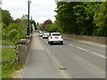
1
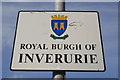
Inverurie town boundary sign
For further heraldic details, see: http://www.electricscotland.com/council/15InnerleithenToIrvine.pdf
The motto "Urbs in Rure" (town in the country) is shared with Solihull,
see: http://www.civicheraldry.co.uk/warwicks_ob.html
Image: © Bill Harrison
Taken: 26 Mar 2012
0.04 miles
2
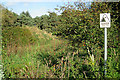
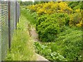
Warning Sign
The maps are pretty misleading here. I expected to see an open watercourse, not a vegetated hollow, but I was not about to experiment to find out how dry, or alternatively how deep, it was. The many warning signs like this one are very necessary.
Image: © Anne Burgess
Taken: 29 Sep 2017
0.05 miles
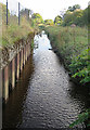
3
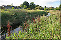
Mill Lade
The canal feeder runs parallel to the mill lade, between the lade and the modern houses on the canal bank.
Image: © Anne Burgess
Taken: 29 Sep 2017
0.06 miles
4
Mill Lade
This is the lade that powered a large flour mill a couple of hundred metres south of here.
Image: © Anne Burgess
Taken: 29 Sep 2017
0.06 miles
5
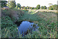
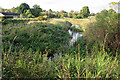
Canal Feeder
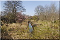
This rather overgrown waterway is the northern part of the canal, through which the canal was supplied with water from a sluice on the River Don. As you can see, it's deep and rather overgrown with vegetation. Not a good place for a swim, voluntarily or otherwise.
Image: © Anne Burgess
Taken: 29 Sep 2017
0.06 miles
6
Bridge over the Lade
This is the original bridge that crossed the mill lade just before it joins the canal.
Image: © Anne Burgess
Taken: 29 Sep 2017
0.07 miles
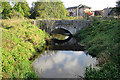
7
Inverurie Bridge
Early 20th century replacement for an 18th century predecessor. See also https://www.geograph.org.uk/photo/7183991
Image: © Alan Murray-Rust
Taken: 22 May 2022
0.07 miles
8
Mill Lade
The lade diverges here from the River Don, but the wall on the left looks too modern to be original.
Image: © Anne Burgess
Taken: 29 Sep 2017
0.08 miles
9
Remains of the Aberdeenshire Canal
The Aberdeenshire Canal, which connected Aberdeen Harbour and Inverurie (Port Elphinstone), opened in 1805 but it was rapidly made obsolete by the railway and it closed in 1854 (see: http://en.wikipedia.org/wiki/Aberdeenshire_Canal ). This fragment, connecting to the River Don at 90 deg in the background, found further use as a lade (millstream).
Image: © Bill Harrison
Taken: 26 Mar 2012
0.08 miles
10
Former mill leat, Port Elphinstone
Taking water from the River Don just below Inverurie Bridge. Apparently not usually as dry as this.
Image: © Alan Murray-Rust
Taken: 22 May 2022
0.08 miles