IMAGES TAKEN NEAR TO
Mintlaw, PETERHEAD, AB42 4JQ
Introduction
This page details the photographs taken nearby to AB42 4JQ by members of the Geograph project.
The Geograph project started in 2005 with the aim of publishing, organising and preserving representative images for every square kilometre of Great Britain, Ireland and the Isle of Man.

There are currently over 7.5m images from over14,400 individuals and you can help contribute to the project by visiting https://www.geograph.org.uk
Image Map
Images are licensed for reuse under creativecommons.org/licenses/by-sa/2.0
Notes
- Clicking on the map will re-center to the selected point.
- The higher the marker number, the further away the image location is from the centre of the postcode.
Image Listing (19 Images Found)
Images are licensed for reuse under creativecommons.org/licenses/by-sa/2.0
Image
Details
Distance
1
New House
A new house is under construction almost on the site of the mansion house, which was demolished in 1929.
Image: © Anne Burgess
Taken: 25 Jun 2018
0.05 miles
2
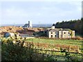
Derelict Farm at Church Park
Derelict farm at Chapel Park near Mintlaw in Aberdeenshire. The chapel in the background has now been converted to a private residence.
Image: © Iain Smith
Taken: 31 Oct 2008
0.08 miles
3
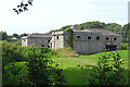
Stable Block
This splendid block was the stables for the mansion of Pitfour nearby. On a grand scale and in classical style, it is Category B listed. There are rumours that there may be plans to restore and develop it, but so far nothing significant has been done.
Image: © Anne Burgess
Taken: 25 Jun 2018
0.08 miles
5
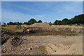
Hole in the Ground
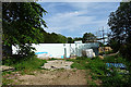
I gather that this hole will in due course become the site of a new house.
Image: © Anne Burgess
Taken: 25 Jun 2018
0.09 miles
6
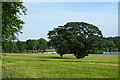
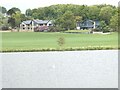
Parkland at Pitfour
The land is now under cultivation, but in its heyday this was part of the vista of lawns sweeping down to the shore of the lake from the mansion house.
Image: © Anne Burgess
Taken: 25 Jun 2018
0.10 miles
7
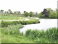
North shore of Pitfour Lake
Looking towards one of the carriageway bridges over the lake.
Image: © Oliver Dixon
Taken: 7 Jun 2021
0.15 miles
8
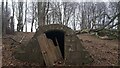
Disused Structure on Pitfour Estate
This low structure is water-related - there were some pipes and what looked like an old ballcock inside. It will no doubt have had something to do with the old reservoirs nearby. Just SouthEast of this spot is a fenced-off area containing a rather mundane new covered reservoir, and a far more impressive (albeit far smaller) curved concrete tank-style one.
Strangely, this tiny building makes it onto the current large-scale OS map, but the functioning covered reservoir does not.
Image: © Ian Dodds
Taken: 13 Feb 2022
0.15 miles
9
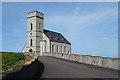
Pitfour Chapel
The chapel was built as a private chapel for the use of the Ferguson family and their estate staff in 1850-1851 after the laid, George Feguson, had fallen out with the Episcopal clergyman at Old Deer. It is one of a few places of worship that belonged to the English Episcopal (continuing) church rather than to the Episcopal Church of Scotland like the majority of Anglican churches in Scotland. It had fallen into disrepair by the 1980s, but was restored in 2003 for use as a house, winning several conservation awards.
Image: © Anne Burgess
Taken: 25 Jun 2018
0.15 miles
10
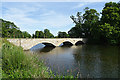
North-east Bridge
One of two bridges built in the early years of the 19th century to carry the drive to Pitfour House over the newly-constructed artificial lake.
Image: © Anne Burgess
Taken: 25 Jun 2018
0.16 miles