IMAGES TAKEN NEAR TO
Station Road, PETERHEAD, AB42 3NE
Introduction
This page details the photographs taken nearby to Station Road, AB42 3NE by members of the Geograph project.
The Geograph project started in 2005 with the aim of publishing, organising and preserving representative images for every square kilometre of Great Britain, Ireland and the Isle of Man.

There are currently over 7.5m images from over14,400 individuals and you can help contribute to the project by visiting https://www.geograph.org.uk
Image Map
Images are licensed for reuse under creativecommons.org/licenses/by-sa/2.0
Notes
- Clicking on the map will re-center to the selected point.
- The higher the marker number, the further away the image location is from the centre of the postcode.
Image Listing (24 Images Found)
Images are licensed for reuse under creativecommons.org/licenses/by-sa/2.0
Image
Details
Distance
1
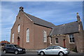
Boddam parish kirk
Dated 1865 with minimalist bellcote but more like Aberdeenshire 'Georgian Gothic' kirks from 60 years earlier such as Echt kirk (http://www.geograph.org.uk/photo/4758650 ) or Kirkton of Skene kirk (http://www.geograph.org.uk/photo/5239085 ). C-listed (LB16314): http://portal.historicenvironment.scot/designation/LB16314 . Update (August 2020): the church is now converted to residential use.
Image: © Bill Harrison
Taken: 19 May 2018
0.11 miles
2
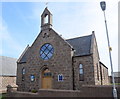
Boddam United Free Church
Built 1881 and originally the free kirk. The UFC was formed in 1900 when the United Presbyterian Church and most of the 1843 Free Church merged: https://en.wikipedia.org/wiki/United_Free_Church_of_Scotland . Most UFC congregations rejoined the Church of Scotland in 1929.
Image: © Bill Harrison
Taken: 19 May 2018
0.12 miles
3
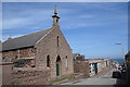
Former Methodist chapel, Gordon Street, Boddam
Boarded up and derelict... Farther down the hill is a wing of the primary school.
Image: © Bill Harrison
Taken: 19 May 2018
0.13 miles
4
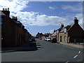
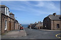
Russell Street in Boddam
A photograph of Russel Street in Boddam, taken at approximately the same spot as one from around 1930, shows how little things have changed in 80 years.
Image: © Iain Smith
Taken: 8 Jun 2009
0.15 miles
5
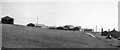
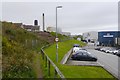
Site of Boddam Station
View southward, towards Ellon; ex-GNS terminus of branch from Ellon, closed long ago (passengers 31/10/32, goods 7/11/45), hence nothing to be seen!
Image: © Ben Brooksbank
Taken: 2 Oct 1961
0.18 miles
6
Looking down New Street, Boddam
Fishermen's cottages made of brown granite from nearby Stirling Hill and beyond them, the sea...
Image: © Bill Harrison
Taken: 19 May 2018
0.18 miles
7
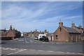
Boddam village centre
Parts of Queen's Road to the left and right with Russell Street bisecting the angle between them and typical 19th Century fishermen's cottages made of brown granite from the adjacent Stirling Hill quarries lining them: 22 Queen's Road to the right of the photo is C-listed (LB16312): http://portal.historicenvironment.scot/designation/LB16312 .
Image: © Bill Harrison
Taken: 19 May 2018
0.19 miles
8
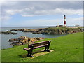
Buchan Ness Lighthouse and Island
Buchan Ness and the lighthouse are seen here from Boddam.
Image: © Richard Slessor
Taken: 26 Apr 2006
0.20 miles
9
Coast path, Boddam
Passing Thistle Seafood.
Image: © Richard Webb
Taken: 1 Aug 2020
0.21 miles
10
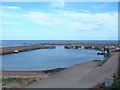
Boddam Harbour
The large harbour just south of Peterhead used to be very busy with the herring fishery, but is now used by only a few small fishing boats and leisure craft.
Image: © Bob Jones
Taken: Unknown
0.21 miles