IMAGES TAKEN NEAR TO
Collieston, ELLON, AB41 8ST
Introduction
This page details the photographs taken nearby to AB41 8ST by members of the Geograph project.
The Geograph project started in 2005 with the aim of publishing, organising and preserving representative images for every square kilometre of Great Britain, Ireland and the Isle of Man.

There are currently over 7.5m images from over14,400 individuals and you can help contribute to the project by visiting https://www.geograph.org.uk
Image Map
Images are licensed for reuse under creativecommons.org/licenses/by-sa/2.0
Notes
- Clicking on the map will re-center to the selected point.
- The higher the marker number, the further away the image location is from the centre of the postcode.
Image Listing (9 Images Found)
Images are licensed for reuse under creativecommons.org/licenses/by-sa/2.0
Image
Details
Distance
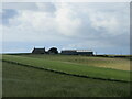
1
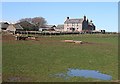
Mains of Slains
The plain but well-proportioned 18th century stone farm house is flanked by both traditional and modern farm buildings.
Image: © Anne Burgess
Taken: 2 Apr 2010
0.01 miles
2
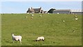
Mains of Slains
The farm house and buildings from a bend in the farm access road. This is another farm built on an elevated and exposed site.
Image: © Anne Burgess
Taken: 2 Jul 2010
0.01 miles
3
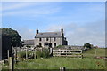
Mains of Slains
The "severe but good proportions" late 18th Century farmhouse is B-listed (LB16052: http://portal.historicenvironment.scot/designation/LB16052 ) and still very much the centre of a working farm.
Image: © Bill Harrison
Taken: 24 Jul 2020
0.02 miles
4
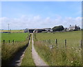
Long walk to Mains of Slains
Visitors to Old Slains Castle (see https://www.geograph.org.uk/photo/6551281 ) can either take the rather precarious coastal path from Collieston or the farm track that passes Mains of Slains.
Image: © Bill Harrison
Taken: 24 Jul 2020
0.02 miles
5
Mains of Slains
Mains of Slains viewed from the road to the north.
Image: © Scott Cormie
Taken: 26 Jul 2022
0.02 miles
6
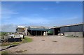
Barns at Mains of Slains ...
... with the ubiquitous rolled straw bales
Image: © Bill Harrison
Taken: 24 Jul 2020
0.05 miles
7
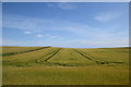
Tractor tracks
The fertile countryside around Collieston supports both arable crops and cattle.
Image: © Bill Harrison
Taken: 24 Jul 2020
0.12 miles
8
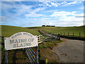
The road to Mains of Slains
The farm of Mains of Slains lies just North of the old fishing village of Collieston. It forms part of Slains Estate on the edge of the North Sea. The land is heavy but highly fertile.
Image: © Martyn Gorman
Taken: 1 Mar 2008
0.15 miles
9
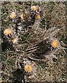
Carline Thistle (Carlina vulgaris)
Although they look as if they are in flower, these are actually last year's dried-up blooms. This is normally a plant of lime, but it is fairly common on the east coast of Scotland, which is on its northern limit.
Image: © Anne Burgess
Taken: 2 Apr 2010
0.23 miles