IMAGES TAKEN NEAR TO
Virginia Street, ABERDEEN, AB11 5AZ
Introduction
This page details the photographs taken nearby to Virginia Street, AB11 5AZ by members of the Geograph project.
The Geograph project started in 2005 with the aim of publishing, organising and preserving representative images for every square kilometre of Great Britain, Ireland and the Isle of Man.

There are currently over 7.5m images from over14,400 individuals and you can help contribute to the project by visiting https://www.geograph.org.uk
Image Map
Images are licensed for reuse under creativecommons.org/licenses/by-sa/2.0
Notes
- Clicking on the map will re-center to the selected point.
- The higher the marker number, the further away the image location is from the centre of the postcode.
Image Listing (765 Images Found)
Images are licensed for reuse under creativecommons.org/licenses/by-sa/2.0
Image
Details
Distance
1
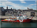
Aberdeen: city view from the Shetland ferry
Looking across Regent Quay and over the granite buildings of the city centre.
Image: © Chris Downer
Taken: 6 Jul 2013
0.00 miles
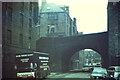
2
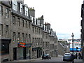
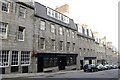
Marischal Street
Famous old street descending from Castlegate to Aberdeen Harbour. This is the city's first flyover, being built on embankments and arches across Virginia Street. These Georgian houses are built of Loanhead granite - quarried in the Rosemount area. The blue ship in the distance is one of the "North Boats" which service Orkney and Shetland.
Image: © Colin Smith
Taken: 9 Apr 2007
0.01 miles
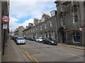
3
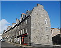
Marischal Street, Aberdeen (east side)
The B-listed houses (see: http://data.historic-scotland.gov.uk/pls/htmldb/f?p=2200:15:0::::BUILDING:20428 ) on the sharply-sloping street connecting the Castlegate and the harbour date from the mid-18th Century.
Image: © Bill Harrison
Taken: 18 Oct 2014
0.01 miles
4
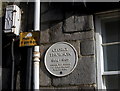
Plaque (37a Marischal Street, Aberdeen)
For more about George Thomson, see this page (http://mcjazz.f2s.com/WhiteStarLine.htm ) on the fantastic Doric Columns website. For the Thomson family memorial (where the name is spelled Thompson) in Dyce burial ground, see: http://www.geograph.org.uk/photo/986485 .
Image: © Bill Harrison
Taken: 18 Oct 2014
0.02 miles
5
Bannerman's Bridge
Old road bridge carrying Marischal Street over Virginia Street in Aberdeen - taken shortly before the bridge was demolished and rebuilt across a dualled Virginia Street.
Note the Shore Porters' Society removals lorry - their base was here in Virginia Street before being moved to nearby Baltic Place. Established in 1498, the porters [originally pynours] carried goods between the town and harbour.
www.aberdeencity.gov.uk
Image: © Colin Smith
Taken: 1 Apr 1982
0.02 miles
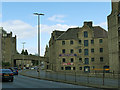
6
Looking up Marischal Street, Aberdeen
Marischal Street, connecting the Castlegate and the harbour, was one of the first "modern" (18th Century) streets in Aberdeen and there are too many listed buildings to list...
Image: © Bill Harrison
Taken: 12 May 2013
0.02 miles
7
A replacement road bridge in Aberdeen
Carrying Marischal Street over Virginia Road (A93) in the vicinity of Aberdeen Harbour. For the bridge it replaced in the 1980's see Image
Image: © Stanley Howe
Taken: 14 May 2015
0.02 miles
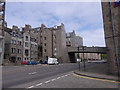
8
Virginia Street, Aberdeen
A dual carriageway road in the city centre, with Marischal Street crossing it on a bridge.
Image: © Stephen Craven
Taken: 1 Jul 2019
0.02 miles
9
Old Blackfriars, Marischal Street
A real ale bar, all too rare in Aberdeen.
Image: © Bill Harrison
Taken: 6 Aug 2009
0.03 miles
10
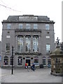
Union Buildings
Grand granite building at the east end of Aberdeen's Union Street. It was designed by Archibald Simpson (1819) and is built in white ashlar granite, in classical style with ionic columns. Union Buildings used to house the Athenaeum (reading library) before becoming Jimmy Hay's Restaurant. Fire in 1973 burnt out the building which was since restored and now is occupied by the Athenaeum pub. The statue on the right is "The Mannie in the Green" - it was sited in The Green in earlier days.
"Before it burnt down it was The Royal Athenaeum restaurant, catering for a select private clientele in the 1960s - civic functions and especially for the "Royals". The "top floor" today was not the top floor, it now does not have the attics which were used for changing rooms, kitchen staff tearooms, dry good store etc. as well as the access to rooftop. In picture, top left was main kitchen, centre window was pantry and the right window was Pastry". [Thanks - John Donaldson].
Image: © Colin Smith
Taken: 9 Apr 2007
0.03 miles