IMAGES TAKEN NEAR TO
Long Street, THIRSK, YO7 3PB
Introduction
This page details the photographs taken nearby to Long Street, YO7 3PB by members of the Geograph project.
The Geograph project started in 2005 with the aim of publishing, organising and preserving representative images for every square kilometre of Great Britain, Ireland and the Isle of Man.

There are currently over 7.5m images from over14,400 individuals and you can help contribute to the project by visiting https://www.geograph.org.uk
Image Map
Images are licensed for reuse under creativecommons.org/licenses/by-sa/2.0
Notes
- Clicking on the map will re-center to the selected point.
- The higher the marker number, the further away the image location is from the centre of the postcode.
Image Listing (91 Images Found)
Images are licensed for reuse under creativecommons.org/licenses/by-sa/2.0
Image
Details
Distance
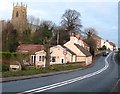
1
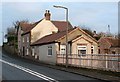
Former Black Bull Inn, Topcliffe
The Black Bull stood opposite the toll house on the way into the village from the south and west. In the 18th century it was the Half Moon. The pub closed to the public in 1982, after which it became a club attached to the caravan site.
Image: © Gordon Hatton
Taken: 30 Dec 2007
0.00 miles
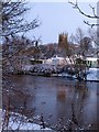
2
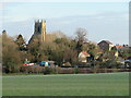
View towards Topcliffe
A view from the Asenby side of the river, the bridge over the Swale being just visible. Beyond is St Columba's Church with the disused Methodist chapel to the right.
Image: © Gordon Hatton
Taken: 7 Jan 2021
0.01 miles
3
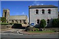
Two Churches
St Columba's and the Methodist Church on opposite sides of Church Street in Topcliffe.
Image: © David Rogers
Taken: 2 Jul 2008
0.02 miles
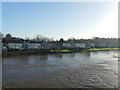
4
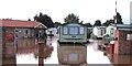
Flooded caravan park, Topcliffe
The flood of late September was record breaking as the Swale rose to its highest level in at least 30 years, flooding the caravan park and its recently constructed reception building, as well as the old toll cottage across the road and the lower floors of Topcliffe Mill a few hundred metres upstream. After this photo was taken the waters rose at least another 30cm.
Image: © Gordon Hatton
Taken: 26 Sep 2012
0.02 miles
5
Old Toll Cottage, Topcliffe
The small cottage in the foreground standing close to the road was built to collect tolls on the Boroughbridge to Northallerton and Darlington turnpike in the mid 18th century. Tolls charged ranged from 2 1/2d for one horse [approx 1p] to 2s 3d [11p] for 4 wheeled wagons drawn by 8 oxen or horse.
Image: © Gordon Hatton
Taken: 30 Dec 2007
0.03 miles
6
Swaleside Holiday Park
The River Swale is very high following a period of heavy rain that caused severe flooding over much of North Yorkshire. The chalets may just have been high enough to avoid being damaged in the flood.
Image: © Graham Hogg
Taken: 29 Dec 2015
0.03 miles
7
The Swale at Topcliffe
Looking across the Swale towards the tower of St Columba's church in Topcliffe.
Image: © Gordon Hatton
Taken: 18 Dec 2009
0.03 miles
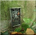
8
Topcliffe bridge
The Flush Bracket, series number 11566, is located on the northern parapet of the bridge at Topcliffe crossing the River Swale. The brass plate is at the eastern end of the bridge, and on the river side, not the road side.
Image: © Mel Towler
Taken: 31 Jul 2021
0.04 miles
9
Topcliffe bridge
This Flush Bracket, series number 11566, is located on the northern parapet of the bridge at Topcliffe crossing the River Swale. The brass plate is at the eastern end of the bridge, and on the river side, not the road side.
Image: © Mel Towler
Taken: 31 Jul 2021
0.04 miles
10
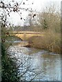
Up river to Topcliffe Bridge
January 2021, and the river is somewhere near a normal level, having recently dropped from flood levels thanks to a spell of drier weather and icy conditions holding back water draining off fields etc. The Swale rarely flows with a consistent level. Being a spate river it either seems to be on the rise or the fall. Drought conditions can see it become so low that one could wade through it, whilst heavy rains upstream can cause it to flood into nearby fields and threaten the riverside holiday park.
Image: © Gordon Hatton
Taken: 7 Jan 2021
0.04 miles