IMAGES TAKEN NEAR TO
Church Street, THIRSK, YO7 3PA
Introduction
This page details the photographs taken nearby to Church Street, YO7 3PA by members of the Geograph project.
The Geograph project started in 2005 with the aim of publishing, organising and preserving representative images for every square kilometre of Great Britain, Ireland and the Isle of Man.

There are currently over 7.5m images from over14,400 individuals and you can help contribute to the project by visiting https://www.geograph.org.uk
Image Map (Loading...)


Getting Data...Please wait
Leaflet Map data © OpenStreetMap
Images are licensed for reuse under creativecommons.org/licenses/by-sa/2.0
Notes
- Clicking on the map will re-center to the selected point.
- The higher the marker number, the further away the image location is from the centre of the postcode.
Image Listing (98 Images Found)
Images are licensed for reuse under creativecommons.org/licenses/by-sa/2.0
Image
Details
Distance
1
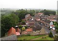
Church Street from above
Looking down from the top of the church tower into Church Street. In the bottom left hand corner is the roof of the former grammar school, whilst in the centre is the three storey house known as The Mount [grade 2 listed] which was once owned by Joseph Dresser, who also owned the local mill. For many years [pre NHS] it was also the doctor's surgery.
Image: © Gordon Hatton
Taken: 8 Jun 2019
0.01 miles
2
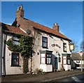
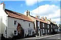
The Swan, Topcliffe
Topcliffe's 'other' pub is the Swan at the top end of Front Street. A modest little establishment that has seen mixed fortunes in recent years, having seen several landlords and short priods of closure. Currently undergoing a bit of a revival.
Image: © Gordon Hatton
Taken: 7 Feb 2009
0.02 miles
4
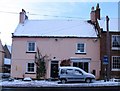
The Old Post House, Topcliffe
An 18th century house on Front Street and marked as the village post office on the 1911 map.
Image: © Gordon Hatton
Taken: 18 Dec 2009
0.03 miles
5
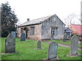
The old grammar school
This building was erected 'by public subscription' in 1812 to replace another school in the churchyard. At the time of building, there were between 70 and 80 boy pupils. Now the church hall.
Image: © Gordon Hatton
Taken: 30 Dec 2007
0.03 miles
6
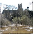
The Swale in flood
Flooding along the lower Swale is not uncommon, but this was the first time the river had burst its banks through the winter/spring of 2018/19 causing the A684 to be closed further upstream at Morton on Swale. This followed one wet day in the local area, but several wet days combined with a little snow melt in Swaledale.
The view is towards St Columba's Church.
Image: © Gordon Hatton
Taken: 17 Mar 2019
0.03 miles
7

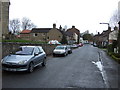
Snowy morning in Front Street
Front Street Topcliffe on a snowy January morning.
Image: © Gordon Hatton
Taken: 9 Jan 2010
0.04 miles
8
The Elm Gallery, Topcliffe
Previously photographed by me in 2009, the building in the foreground, once the village post office, is now a small art gallery and shop.
Image: © Gordon Hatton
Taken: 26 Oct 2018
0.04 miles
10
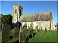
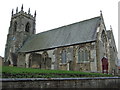
St Columba's Church, Topcliffe
Grade II* listed dating from the 13th century
Image: © Graham Hogg
Taken: 29 Dec 2015
0.04 miles