IMAGES TAKEN NEAR TO
Hawnby, YORK, YO62 5QX
Introduction
This page details the photographs taken nearby to YO62 5QX by members of the Geograph project.
The Geograph project started in 2005 with the aim of publishing, organising and preserving representative images for every square kilometre of Great Britain, Ireland and the Isle of Man.

There are currently over 7.5m images from over14,400 individuals and you can help contribute to the project by visiting https://www.geograph.org.uk
Image Map
Images are licensed for reuse under creativecommons.org/licenses/by-sa/2.0
Notes
- Clicking on the map will re-center to the selected point.
- The higher the marker number, the further away the image location is from the centre of the postcode.
Image Listing (37 Images Found)
Images are licensed for reuse under creativecommons.org/licenses/by-sa/2.0
Image
Details
Distance
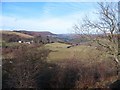
1
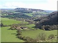
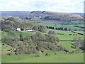
Peak Scar Top view 3
This is the view north eastwards from the vantage point of Peak Scar Top. Below is the farm at Dale Town, whilst in the middle distance the village of Hawnby straggles up the hillside. In the distance is the 'twin' of Hawnby Hill [view 2], this being Easterside, some 15m higher than its neighbour, and also an outlier of the Tabular Hills.
Image: © Gordon Hatton
Taken: 28 Apr 2016
0.01 miles
2
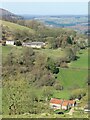
Looking down to Dale Town
Dale Town is the property nearest the camera, but for much of the way around Peak Scar it is invisible from above due to the hillside contours. One wonders how much sunlight reaches the property in mid winter. The white house beyond is Daleside.
Image: © Gordon Hatton
Taken: 22 Mar 2021
0.01 miles
3
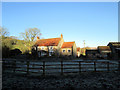
Blue sky sunshine and a heavy frost
Dale Town Farm in sunshine and shadow
Image: © Martin Dawes
Taken: 3 Dec 2014
0.02 miles
4
Dale town from Peak Scar Road near Hawnby
Image: © Colin Park
Taken: 18 Sep 1981
0.02 miles
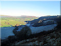
5

Dale Town
A working farm nestling below Peak Scar. The name implies that there was a more substantial settlement here. There is documentary evidence that there was a settlement in the 11c. Hawnby Hill dominates the horizon.
Image: © Mick Garratt
Taken: 21 Jan 2007
0.03 miles
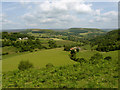
6
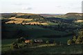
Peak Scar Top view 2
The view here is across Gowerdale towards Daleside farm [white house centre left], with Hawnby Hill in the distance. Hawnby Hill is a very satisfying little hill to climb, with all round views, a narrow ridge top and even some small limestone outcrops.
Image: © Gordon Hatton
Taken: 28 Apr 2016
0.09 miles
7
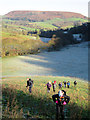
The climb to Dale Town Farm
Into bright sun from the frosty shadowed dale.Easterside Hill stands proudly in the distance.
Image: © Martin Dawes
Taken: 3 Dec 2014
0.09 miles
9
Very much a contrast in December sunshine
The low sun will not reach the north facing side of the dale rising up to High Peak Top. Dale Town Farm is just in the sunlight, the village beyond is Hawnby with Hawnby Hill to the left and Easterside Hill to the right of the village.Beef cattle were still out in the fields but they will be going into the sheds now the weather has turned colder.
Image: © Martin Dawes
Taken: 3 Dec 2014
0.11 miles
10
The view from Murton Bank top
Looking over Plumpton Wood towards Sunnybank Farm and upper Ryedale from the scarp edge.
Image: © Gordon Hatton
Taken: 3 Feb 2011
0.14 miles