IMAGES TAKEN NEAR TO
Western View, YO42 2WP
Introduction
This page details the photographs taken nearby to Western View, YO42 2WP by members of the Geograph project.
The Geograph project started in 2005 with the aim of publishing, organising and preserving representative images for every square kilometre of Great Britain, Ireland and the Isle of Man.

There are currently over 7.5m images from over14,400 individuals and you can help contribute to the project by visiting https://www.geograph.org.uk
Image Map
Images are licensed for reuse under creativecommons.org/licenses/by-sa/2.0
Notes
- Clicking on the map will re-center to the selected point.
- The higher the marker number, the further away the image location is from the centre of the postcode.
Image Listing (33 Images Found)
Images are licensed for reuse under creativecommons.org/licenses/by-sa/2.0
Image
Details
Distance
1
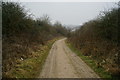
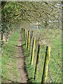
The Chalkland Way, Pocklington
Looking east-northeast along the footpath at the southern boundary of Kilnwick Percy Golf Club. The Chalkland Way is a 40-mile circular walk starting and finishing at Pocklington. The route was established in 1994 by the East Yorkshire and Derwent Area of The Ramblers' Association.
Image: © Paul Glazzard
Taken: 17 Oct 2007
0.04 miles
2
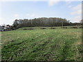
Woodland on Chapel Hill, Pocklington
Image: © Jonathan Thacker
Taken: 14 Apr 2018
0.06 miles
3
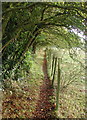
Bunker on Kilnwick Percy Golf Course
The white posts on the left are the plastic sleeves around young hedge saplings, probably to protect the end of the golfcourse. I am on the footpath which is also the route of the Chalklands Way and the Wilberforce Way.
Image: © Martin Dawes
Taken: 15 Mar 2017
0.08 miles
4
The Chalkland Way
This part of The Chalkland Way is between Pocklington and Kilnwick Percy, adjacent to Kilnwick Percy Golf Course.
Image: © bernard bradley
Taken: 20 Mar 2009
0.09 miles
5
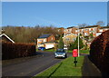
St Helen's Road, Pocklington
Showing position of Postbox No. YO42 552.
See Image] for postbox.
Image: © JThomas
Taken: 16 Dec 2021
0.10 miles
6

Elizabeth II postbox on St Helen's Road, Pocklington
Image: © JThomas
Taken: 16 Dec 2021
0.11 miles
7
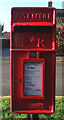
Close up, Elizabeth II postbox on St Helen's Road, Pocklington
Postbox No. YO42 552.
See Image] for wider view.
Image: © JThomas
Taken: 16 Dec 2021
0.11 miles
8
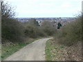
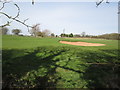
Down hill all the way
Looking down from Chapel Hill along a track which forms part of the Chalkland Way. Right middle distance is the square tower of All Saints Church in the centre of Pocklington clearly visible.
Image: © bernard bradley
Taken: 1 Apr 2008
0.12 miles
9
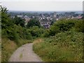
The Chalkland Way into Pocklington
The footpath of the Chalkland Way descends from Chapel Hill into Pocklington.
Image: © Dr Patty McAlpin
Taken: 26 Jul 2009
0.12 miles