IMAGES TAKEN NEAR TO
Wilton Rise, YORK, YO24 4BT
Introduction
This page details the photographs taken nearby to Wilton Rise, YO24 4BT by members of the Geograph project.
The Geograph project started in 2005 with the aim of publishing, organising and preserving representative images for every square kilometre of Great Britain, Ireland and the Isle of Man.

There are currently over 7.5m images from over14,400 individuals and you can help contribute to the project by visiting https://www.geograph.org.uk
Image Map
Images are licensed for reuse under creativecommons.org/licenses/by-sa/2.0
Notes
- Clicking on the map will re-center to the selected point.
- The higher the marker number, the further away the image location is from the centre of the postcode.
Image Listing (313 Images Found)
Images are licensed for reuse under creativecommons.org/licenses/by-sa/2.0
Image
Details
Distance
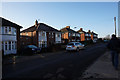
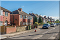
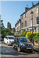
2
Wilton Rise
Semi-detached housing built in the 1930s on a section of road connecting the Victorian terraced housing of Wilton Street (seen in the left background) with Holgate Road, with the name Wilton Rise in time being applied to the whole road.
Image: © Ian Capper
Taken: 18 Jul 2017
0.02 miles
3
Enfield Crescent
Cul-de-sac (despite the name) off St Paul's Square. The 1937 1:2,500 map show the area round the corner to the left as an "Intrenchment" (sic), with "Medieval Pottery &c. found A.D. 1936". Although no development of this road is shown on that map, this suggests that work might have started soon after, if the discovery was part of pre-development archaeological work.
Image: © Ian Capper
Taken: 17 Aug 2019
0.03 miles
4
Enfield Crescent
Looking along Enfield Crescent behind St. Paul's Terrace.
Image: © DS Pugh
Taken: 20 Dec 2021
0.03 miles
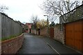
5
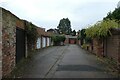
Garages on Enfield Crescent
Looking along a back street behind St. Paul's Square.
Image: © DS Pugh
Taken: 20 Dec 2021
0.03 miles
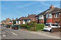
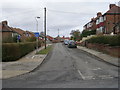
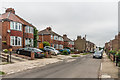
6
Wilton Rise
Semi-detached housing built in the 1930s on a section of road connecting the Victorian terraced housing of Wilton Street (see Image) with Holgate Road, with the name Wilton Rise in time being applied to the whole road.
Image: © Ian Capper
Taken: 20 Jul 2017
0.04 miles
8
St. Paul's Square
Looking along a terrace overlooking a park.
Image: © DS Pugh
Taken: 14 Mar 2021
0.06 miles
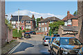
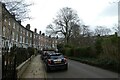
9
St Paul's Square
York's only "square", built c1855 and consisting of three storeyed terraced houses built in an elongated crescent surrounding a private central garden of lawn, shrubs and mature trees. Almost all the buildings are grade II listed. These houses are on the western arm of the crescent of the square: nearest on the right of the photo is no 33 - see www.historicengland.org.uk/listing/the-list/list-entry/1256749; and then no 34 - see www.historicengland.org.uk/listing/the-list/list-entry/1256750. The terrace beyond, nos 35 - 37 were a later addition, in the c1870s - see www.historicengland.org.uk/listing/the-list/list-entry/1256751.
Image: © Ian Capper
Taken: 17 Aug 2019
0.06 miles
10
Wilton Rise
Semi-detached housing built in the 1930s on a section of road connecting the Victorian terraced housing of Wilton Street (seen in the right background) with Holgate Road, with the name Wilton Rise in time being applied to the whole road.
Image: © Ian Capper
Taken: 19 Jul 2017
0.06 miles