IMAGES TAKEN NEAR TO
Underhill, WHITBY, YO21 2PH
Introduction
This page details the photographs taken nearby to Underhill, YO21 2PH by members of the Geograph project.
The Geograph project started in 2005 with the aim of publishing, organising and preserving representative images for every square kilometre of Great Britain, Ireland and the Isle of Man.

There are currently over 7.5m images from over14,400 individuals and you can help contribute to the project by visiting https://www.geograph.org.uk
Image Map
Images are licensed for reuse under creativecommons.org/licenses/by-sa/2.0
Notes
- Clicking on the map will re-center to the selected point.
- The higher the marker number, the further away the image location is from the centre of the postcode.
Image Listing (42 Images Found)
Images are licensed for reuse under creativecommons.org/licenses/by-sa/2.0
Image
Details
Distance
1
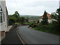
The steep road down to Lower Under Hill, Glaisdale
Dropping 60 metres in about 250 metres. Signed for 'Local traffic only'.
Image: © Christine Johnstone
Taken: 8 Jun 2019
0.01 miles
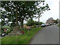
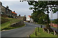
2
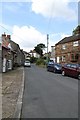
Street in Glaisdale
Narrow street in Glaisdale
Image: © Graeme Smith
Taken: 12 Jun 2011
0.02 miles
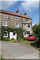
3
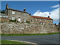
Houses, Glaisdale
The one on the right was probably a former public house with a bracket for a sign, car park at the back and windows that look like a toilet block.
Image: © Chris Allen
Taken: 21 Jul 2010
0.04 miles
4
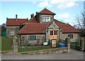
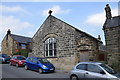
Robinson Institute, Glaisdale
An impressive village hall
Image: © Paul Buckingham
Taken: 2 Apr 2008
0.05 miles
5
The Old Forge
The Old Forge, Glaisdale
Image: © Graeme Smith
Taken: 12 Jun 2011
0.05 miles
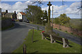
6
War memorial, Glaisdale
Inscribed 'To the memory of the men of Glaisdale who fell in the Great War 1914 -1919 / Jesu blest grant them in thy love to rest / John Bonas. William J. M. Child. James Jefferson. John Pearson. Ralph Scarth. / Charles E. Scanlon. John H. Scarth. Frederick W. Scarth. Francis R. Scarth. / William Ward. Ernest Wilson. Pennock Winspear. Harry Winspear.' Francis R. Scarth is buried in the nearby churchyard Image
Image: © Christine Johnstone
Taken: 8 Jun 2019
0.06 miles
9
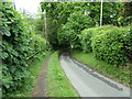
Raised pavement on the road to Lower Under Hill
The gradient is mapped at 14 - 20%, so the handrail could be useful.
Image: © Christine Johnstone
Taken: 8 Jun 2019
0.08 miles