IMAGES TAKEN NEAR TO
Ackworth Street, SCARBOROUGH, YO12 5EP
Introduction
This page details the photographs taken nearby to Ackworth Street, YO12 5EP by members of the Geograph project.
The Geograph project started in 2005 with the aim of publishing, organising and preserving representative images for every square kilometre of Great Britain, Ireland and the Isle of Man.

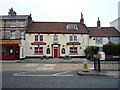
There are currently over 7.5m images from over14,400 individuals and you can help contribute to the project by visiting https://www.geograph.org.uk
Image Map
Images are licensed for reuse under creativecommons.org/licenses/by-sa/2.0
Notes
- Clicking on the map will re-center to the selected point.
- The higher the marker number, the further away the image location is from the centre of the postcode.
Image Listing (187 Images Found)
Images are licensed for reuse under creativecommons.org/licenses/by-sa/2.0
Image
Details
Distance
1
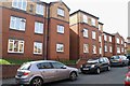
Sitwell Court, Sitwell Street
Sitwell Court is a development of sheltered flats on the site of the girls and infants part of the former Falsgrave Board School; the former boys part on the opposite side of the street is still extant as a building and is shown in Image
Image: © Christopher Hall
Taken: 28 Apr 2014
0.01 miles
2
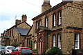
Former police station, Falsgrave
When Falsgrave was a separate township from Scarborough, it was policed by the North Riding Constabulary rather than the Municipal police force. The buildings are now houses ,but they were built in 1882 as a police station and ploice houses to designs by Walter Stead. There is a large yard behind accessed between the two blocks
Image: © Christopher Hall
Taken: 26 Jun 2008
0.01 miles
3
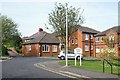
Sitwell Court from Acworth Street
Another view of Sitwell Court sheltered accommodation, which is also shown in Image This is the entrance to the site from Acworth Street.
Image: © Christopher Hall
Taken: 28 Apr 2014
0.01 miles
4
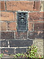
Flush Bracket 0296 S, Sitwell Street, Scarborough
This Ordnance Survey flush bracket is on the south west corner of the former Falsgrave Board School in Sitwell Street - see Image
Image: © John S Turner
Taken: 30 Jun 2014
0.03 miles
5
The New Tavern, Scarborough
On Falsgrave Road.
Image: © JThomas
Taken: 20 Feb 2016
0.03 miles
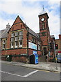
6
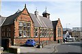
Former Falsgrave Board School, Sitwell Street
This is the Sitwell Street elevation of the former Falsgrave Board School built in 1872 to designs by Wakefield Architect William Watson. This was the boys part of the school; girls and infants were in a separate building. The traffic lights mark the junction of Falsgrave Road and Seamer Road and the white building in the background is the Tap & Spile PH. The former school is now a retail bed warehouse
Image: © Christopher Hall
Taken: 28 Apr 2014
0.04 miles
7
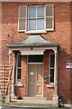
Detail of the porch to Tynedale
This is the porch to the house shown in Image It has seen better days but is still a nice feature.
Image: © Christopher Hall
Taken: 28 Apr 2014
0.04 miles
8
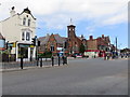
Falsgrave Road junction with Seamer Road
Looking across Falsgrave Road at its junction with Seamer Road. On the opposite corner with Sitwell Street stands the former Falsgrave Board School, which was built in 1872.
Image: © John S Turner
Taken: 30 Jun 2014
0.04 miles
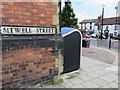
9
Former Falsgrave Board School entrance
Looking across Sitwell Street towards the southern end and entrance to the former Falsgrave Board School. To the left of the blue recycling container there is an Ordnance Survey Flush Bracket set into the brickwork.
Image: © John S Turner
Taken: 30 Jun 2014
0.04 miles
10
The corner of the former Falsgrave Board School
The corner of Sitwell Street with Falsgrave Road, with the corner of the former board school on the left. Near the bottom of the wall there is an Ordnance Survey Flush Bracket - see Image
Image: © John S Turner
Taken: 30 Jun 2014
0.04 miles