IMAGES TAKEN NEAR TO
Cemetery Road, YORK, YO10 5AJ
Introduction
This page details the photographs taken nearby to Cemetery Road, YO10 5AJ by members of the Geograph project.
The Geograph project started in 2005 with the aim of publishing, organising and preserving representative images for every square kilometre of Great Britain, Ireland and the Isle of Man.

There are currently over 7.5m images from over14,400 individuals and you can help contribute to the project by visiting https://www.geograph.org.uk
Image Map
Images are licensed for reuse under creativecommons.org/licenses/by-sa/2.0
Notes
- Clicking on the map will re-center to the selected point.
- The higher the marker number, the further away the image location is from the centre of the postcode.
Image Listing (243 Images Found)
Images are licensed for reuse under creativecommons.org/licenses/by-sa/2.0
Image
Details
Distance
1
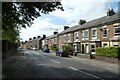
Houses along Cemetery Road
Looking along Cemetery Road towards Fulford Road.
Image: © DS Pugh
Taken: 2 Sep 2021
0.04 miles
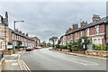
2
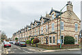
Howard Street
Uniform Late Victorian three-storeyed terrace in a cul-de-sac off Fulford Road.
Image: © Ian Capper
Taken: 4 Feb 2023
0.05 miles
3

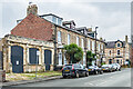
Fulford District Conservative Club
The building stands on a busy corner between Fulford Road and Cemetery Road and dates from 1810.
Image: © Gordon Hatton
Taken: 8 Feb 2009
0.05 miles
6
81 - 87 Fulford Road
Victorian terrace first shown on the 1891 1:500 Town Plan when it was marked as part of Chelmsford Place.
The row of arches on the left has an unusual history, coming originally from the York Theatre Royal, where a row of eight arches were included as part of a new façade to the theatre on to St Leonard's Place built in 1834 designed by the architect John Harper. The theatre was subsequently remodelled in 1879 and seven of the arches were relocated to create a decorative screen along the Fulford Road frontage of gardens to Manor House (now 73 Fulford Road off to the left of this photo, forming part of what is now called Saxon House), also including access to the coach houses of The Priory, a building on the opposite side of Fulford Road (see Image). In 1979 a four-storey block of flats, Ellwood Court, was built on the site of the Manor House gardens and it seems that the left hand section of the arches were removed then (if not before), leaving just the three remaining ones seen here (and a very short section of wall the other side of Ellwood Court). The remaining section of the site, including the coach houses, has seen various uses over the years, including a car store, car repair and cycle workshop for the coach houses and the addition of building behind the arches, which from 1992 housed a children's day nursery, "Pipkins". The whole site was sold in 2017 and proposals are in place for redevelopment, incorporating the arches, which were restored in 2020.
Image: © Ian Capper
Taken: 4 Feb 2023
0.07 miles
7

A Fulford Road oddity
A strange looking building on Fulford Road currently used as a nursery for infants. The building's frontage was at one time part of an arcade in front of the Theatre Royal in St Leonard's Place and dates from 1835. It was removed here in 1879, but for what purpose?
Image: © Gordon Hatton
Taken: 8 Feb 2009
0.07 miles
8
Fulford Road
Late Victorian housing in Fulford Road, built c.1870, with those on the right shown on the 1891 1:500 Town Plan as Grange Crescent having been built on part of what was the Fulford Grange estate.
Image: © Ian Capper
Taken: 4 Feb 2023
0.07 miles
10

Fulford District Conservative Club
Former house at the junction of Fulford Road and Cemetery Road, built c.1810. Grade II listed - see https://historicengland.org.uk/listing/the-list/list-entry/1257802?section=official-list-entry.
Image: © Ian Capper
Taken: 4 Feb 2023
0.08 miles