IMAGES TAKEN NEAR TO
Boundary Close, WOLVERHAMPTON, WV5 7EH
Introduction
This page details the photographs taken nearby to Boundary Close, WV5 7EH by members of the Geograph project.
The Geograph project started in 2005 with the aim of publishing, organising and preserving representative images for every square kilometre of Great Britain, Ireland and the Isle of Man.

There are currently over 7.5m images from over14,400 individuals and you can help contribute to the project by visiting https://www.geograph.org.uk
Image Map
Images are licensed for reuse under creativecommons.org/licenses/by-sa/2.0
Notes
- Clicking on the map will re-center to the selected point.
- The higher the marker number, the further away the image location is from the centre of the postcode.
Image Listing (111 Images Found)
Images are licensed for reuse under creativecommons.org/licenses/by-sa/2.0
Image
Details
Distance
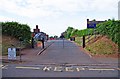
1
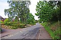
Aston Lane, Claverley
This is the more modern part of the village. There is a lot of fairly recent housing development on the north side of Aston Lane.
Image: © P L Chadwick
Taken: 11 Jun 2011
0.02 miles
2
Griffiths Green
The view in the lane of Claverley village.
Image: © Gordon Griffiths
Taken: 15 Nov 2014
0.07 miles
3
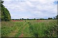
Field by Orchard Close, Claverley
There is a public footpath across this field, which someone in the distance is using to exercise their dog. The photograph was taken from the Orchard Close access to the field. Behind the hedge on the left runs Aston Lane.
Image: © P L Chadwick
Taken: 11 Jun 2011
0.08 miles
4
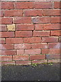
OS benchmark - Griffiths Green, outbuilding
AN OS cutmark on the wall of an outbuilding belonging to no 8 Griffiths Green; originally levelled at 74.734m above Ordnance Datum Newlyn.
Image: © Richard Law
Taken: 31 Jan 2015
0.08 miles
5
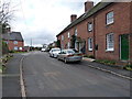
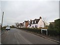
Griffithsgreen, Claverley
A row of (probably) 19th century terraced cottages at the roadside. Some refurbishment work was taking place inside the middle one on this particular day.
Image: © Richard Law
Taken: 31 Jan 2015
0.09 miles
6
Claverly Church of England Primary School - school gates, Aston Lane, Claverley
The school has about 120 pupils, aged 5 to 11. It is a Shropshire Council maintained Church of England primary school.
Image
Image: © P L Chadwick
Taken: 11 Jun 2011
0.09 miles
7

Claverly Church of England Primary School, Aston Lane, Claverley
This modern primary school was photographed from the school gates.
Image
Image: © P L Chadwick
Taken: 11 Jun 2011
0.09 miles
8
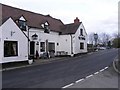
The Plough Claverley
One of three Pubs in this small Village.
Image: © Gordon Griffiths
Taken: 26 Feb 2010
0.12 miles
9
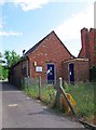
B T telephone exchange, Orchard Close, Claverley
The building is an automated telephone exchange. It has a notice attached saying it is B T premises. The days when telephone exchanges had people sitting in them inserting and removing plugs into switchboards, as would have been the case 60 or more years ago, are of course long gone!
Image: © P L Chadwick
Taken: 11 Jun 2011
0.13 miles
10
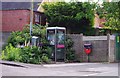
A corner of Claverley
This scene is on the corner of Orchard Close and Aston Lane. Included is a B T telephone kiosk, of a modern type, a dog waste bin, a street sign and a grey box, which may be something to do with telephones, and a lot of out of control vegetation. Behind them is an electricity substation.
Image: © P L Chadwick
Taken: 11 Jun 2011
0.13 miles