IMAGES TAKEN NEAR TO
Lodge Park, WOLVERHAMPTON, WV5 7DP
Introduction
This page details the photographs taken nearby to Lodge Park, WV5 7DP by members of the Geograph project.
The Geograph project started in 2005 with the aim of publishing, organising and preserving representative images for every square kilometre of Great Britain, Ireland and the Isle of Man.

There are currently over 7.5m images from over14,400 individuals and you can help contribute to the project by visiting https://www.geograph.org.uk
Image Map
Images are licensed for reuse under creativecommons.org/licenses/by-sa/2.0
Notes
- Clicking on the map will re-center to the selected point.
- The higher the marker number, the further away the image location is from the centre of the postcode.
Image Listing (169 Images Found)
Images are licensed for reuse under creativecommons.org/licenses/by-sa/2.0
Image
Details
Distance
1
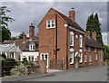
Old housing in Claverley, Shropshire
These cottages are in High Street, which is not the shopping centre of the village, but just a street leading to higher land. The tall house in fine condition has the date 1779 on it and is Grade II listed. The further two have been knocked into one, and doorways to the road bricked up.
Image: © Roger D Kidd
Taken: 24 Jun 2011
0.03 miles
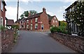
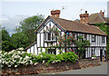
2

The Dormers
The Claverley house in High Street.
Image: © Gordon Griffiths
Taken: 10 May 2010
0.07 miles
3
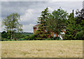
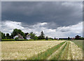
Barley field and house near Claverley, Shropshire
The house is the south-west corner one in Lodge Park, where properties are of substantial proportions.
Image: © Roger D Kidd
Taken: 24 Jun 2011
0.09 miles
4
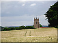
Barley field with church tower by Claverley, Shropshire
This telephoto assisted image from the middle of the barley field shows the South Shropshire landscape with the 12th/15th century tower of All Saints Church dominating the skyline.
A wide angle view can be seen here: Image]
Image: © Roger D Kidd
Taken: 24 Jun 2011
0.10 miles
5
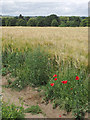
Farmland near Claverley, Shropshire
Barley is growing on this side of the track (which is a public footpath), but it looks a bit dry and may have suffered from low spring rainfall. Behind the track, no crop has been planted, so many meadow flowers and grasses thrive.
Image: © Roger D Kidd
Taken: 24 Jun 2011
0.10 miles
6
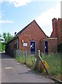
B T telephone exchange, Orchard Close, Claverley
The building is an automated telephone exchange. It has a notice attached saying it is B T premises. The days when telephone exchanges had people sitting in them inserting and removing plugs into switchboards, as would have been the case 60 or more years ago, are of course long gone!
Image: © P L Chadwick
Taken: 11 Jun 2011
0.11 miles
7
Road junction, Claverley
The junction of High Street and Aston Lane. In the foreground is High Street. This continues to the right, by the junction. Aston Lane starts at that point, and is the road turning to the left. Most of the High Street is residential, unlike most High Streets.
Image: © P L Chadwick
Taken: 11 Jun 2011
0.11 miles
8
Footpath across farm land near Claverley, Shropshire
The field is planted with barley on the left this year, looking distinctly dry,while on the right it has been left unplanted so many meadow plants including poppies and cornflower are thriving. The footpath is approaching the lane at the south end of High Street, Claverley. This is not the shopping centre of the village, but a street leading from the village to higher ground.
I like it when the foreground is bathed in sunshine while the distance has threatening clouds. It didn't actually rain because this dark beauty passed over.
Image: © Roger D Kidd
Taken: 24 Jun 2011
0.11 miles
9
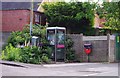
A corner of Claverley
This scene is on the corner of Orchard Close and Aston Lane. Included is a B T telephone kiosk, of a modern type, a dog waste bin, a street sign and a grey box, which may be something to do with telephones, and a lot of out of control vegetation. Behind them is an electricity substation.
Image: © P L Chadwick
Taken: 11 Jun 2011
0.11 miles
10
Timbered cottages in Claverley, Shropshire
These buildings are situated at the junction of Church Street with High Street. Aston Lane is behind the camera.
Image: © Roger D Kidd
Taken: 24 Jun 2011
0.11 miles