IMAGES TAKEN NEAR TO
Aston Lane, WOLVERHAMPTON, WV5 7BE
Introduction
This page details the photographs taken nearby to Aston Lane, WV5 7BE by members of the Geograph project.
The Geograph project started in 2005 with the aim of publishing, organising and preserving representative images for every square kilometre of Great Britain, Ireland and the Isle of Man.

There are currently over 7.5m images from over14,400 individuals and you can help contribute to the project by visiting https://www.geograph.org.uk
Image Map
Images are licensed for reuse under creativecommons.org/licenses/by-sa/2.0
Notes
- Clicking on the map will re-center to the selected point.
- The higher the marker number, the further away the image location is from the centre of the postcode.
Image Listing (19 Images Found)
Images are licensed for reuse under creativecommons.org/licenses/by-sa/2.0
Image
Details
Distance
1
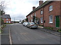
Griffithsgreen, Claverley
A row of (probably) 19th century terraced cottages at the roadside. Some refurbishment work was taking place inside the middle one on this particular day.
Image: © Richard Law
Taken: 31 Jan 2015
0.00 miles
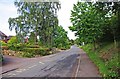
2
Griffiths Green
The view in the lane of Claverley village.
Image: © Gordon Griffiths
Taken: 15 Nov 2014
0.01 miles
3
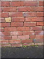
OS benchmark - Griffiths Green, outbuilding
AN OS cutmark on the wall of an outbuilding belonging to no 8 Griffiths Green; originally levelled at 74.734m above Ordnance Datum Newlyn.
Image: © Richard Law
Taken: 31 Jan 2015
0.02 miles
4
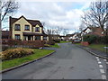
Ex-council semis, Danford Heath
A small estate of former council properties on the eastern side of Claverley; the road name is Danford Heath.
Image: © Richard Law
Taken: 31 Jan 2015
0.08 miles
5
Clover Heath, Claverley
1950s or 60s bungalows on the eastern side of Claverley.
Image: © Richard Law
Taken: 31 Jan 2015
0.10 miles
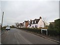
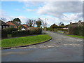
6
Aston Lane, Claverley
This is the more modern part of the village. There is a lot of fairly recent housing development on the north side of Aston Lane.
Image: © P L Chadwick
Taken: 11 Jun 2011
0.10 miles
7
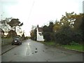
Danford Lane
The view down the lane towards the village of Claverley.
Image: © Gordon Griffiths
Taken: 15 Nov 2014
0.13 miles
8
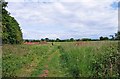
Field by Orchard Close, Claverley
There is a public footpath across this field, which someone in the distance is using to exercise their dog. The photograph was taken from the Orchard Close access to the field. Behind the hedge on the left runs Aston Lane.
Image: © P L Chadwick
Taken: 11 Jun 2011
0.16 miles
9
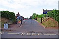
Claverly Church of England Primary School - school gates, Aston Lane, Claverley
The school has about 120 pupils, aged 5 to 11. It is a Shropshire Council maintained Church of England primary school.
Image
Image: © P L Chadwick
Taken: 11 Jun 2011
0.17 miles
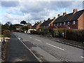
10
Danesbrook, Claverley
Recently-built housing on the east side of Claverley
Image: © Richard Law
Taken: 31 Jan 2015
0.17 miles