IMAGES TAKEN NEAR TO
Ludlow Gate, BRIDGNORTH, WV16 5AB
Introduction
This page details the photographs taken nearby to Ludlow Gate, WV16 5AB by members of the Geograph project.
The Geograph project started in 2005 with the aim of publishing, organising and preserving representative images for every square kilometre of Great Britain, Ireland and the Isle of Man.

There are currently over 7.5m images from over14,400 individuals and you can help contribute to the project by visiting https://www.geograph.org.uk
Image Map
Images are licensed for reuse under creativecommons.org/licenses/by-sa/2.0
Notes
- Clicking on the map will re-center to the selected point.
- The higher the marker number, the further away the image location is from the centre of the postcode.
Image Listing (21 Images Found)
Images are licensed for reuse under creativecommons.org/licenses/by-sa/2.0
Image
Details
Distance
1
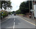
NE end of Ludlow Road, Bridgnorth
The sign pointing along the B4364 shows 19 (miles) to Ludlow.
Image: © Jaggery
Taken: 2 Jul 2014
0.12 miles
3
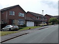
Houses in The Wheatfields, Bridgnorth
Near Bridgnorth Police Station. http://www.geograph.org.uk/photo/4065765
Image: © Jaggery
Taken: 2 Jul 2014
0.16 miles
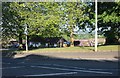
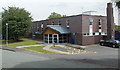
5
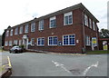
Shropshire Council offices in Westgate, Bridgnorth
On the south side of Wenlock Road.
Image: © Jaggery
Taken: 2 Jul 2014
0.17 miles
6
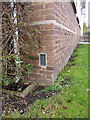
OS Flush Bracket G2200, former Bridgnorth council offices
OS Flush Bracket G2200 on the south-facing wall of the former District Council offices on Ludlow Road. Originally levelled at 76.443m above Ordnance Datum Newlyn, and used during the 3rd Geodetic Levelling of England and Wales between 1950 - 1968.
Image: © Richard Law
Taken: 25 Jan 2014
0.17 miles
7
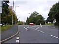
Ludlow Road junction, Bridgnorth
Salop Street changes into Wenlock Road ahead.
Image: © Peter Whatley
Taken: 12 May 2012
0.17 miles
8
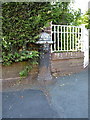
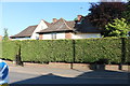
Water conduit head on Ludlow Road
This Grade II listed https://britishlistedbuildings.co.uk/101392279-conduit-head-corner-of-westgate-and-ludlow-road-bridgnorth#.XRieM-hKjct & https://historicengland.org.uk/listing/the-list/list-entry/1392279 black pipehead represents a visible portion of the mid-19th century public water supply system installed throughout Bridgnorth from the 1850s onwards. The basis of the system was a pumped arrangement to bring water from the Severn to a filtration works above the town. This was connected to a network of pipes extending through the town, and dispensed through conduit heads such as this in a variety of strategic locations. A couple survive - the one seen here, and another listed one in the middle of the town at Image There is also a similar (pump-handled) head to the north of Low Town, now demoted to a decorative feature in a flowerbed near the junction of Stanley Lane and Bramble Ridge.
Image: © Richard Law
Taken: 21 Jun 2019
0.18 miles
9
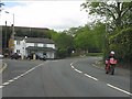
Ludlow Road View
The view on the Bridgnorth road near the A458 junction.
Image: © Gordon Griffiths
Taken: 9 Oct 2012
0.18 miles
10
Bridgnorth Police Station
Part of the West Mercia Police force, viewed across The Wheatlands.
Image: © Jaggery
Taken: 2 Jul 2014
0.18 miles