IMAGES TAKEN NEAR TO
Alveley, BRIDGNORTH, WV15 6HH
Introduction
This page details the photographs taken nearby to WV15 6HH by members of the Geograph project.
The Geograph project started in 2005 with the aim of publishing, organising and preserving representative images for every square kilometre of Great Britain, Ireland and the Isle of Man.

There are currently over 7.5m images from over14,400 individuals and you can help contribute to the project by visiting https://www.geograph.org.uk
Image Map
Images are licensed for reuse under creativecommons.org/licenses/by-sa/2.0
Notes
- Clicking on the map will re-center to the selected point.
- The higher the marker number, the further away the image location is from the centre of the postcode.
Image Listing (15 Images Found)
Images are licensed for reuse under creativecommons.org/licenses/by-sa/2.0
Image
Details
Distance
1
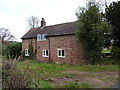
Yewtree Cottage, Alveley
Just outside the village on the lane that loops around to the NW, Yewtree Cottage is mainly built of coarsely dressed local sandstone, and appears to date from the late 18th or early 19th century. The chimney must mark the original extent of the cottage, whilst the brick extension beyond it on the left will be a more recent addition.
Image: © Richard Law
Taken: 3 Dec 2017
0.01 miles
2
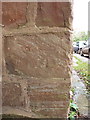
OS benchmark - Alveley, Yewtree Cottage
The rather weathered and faded remains of an OS cutmnark on the front wall of the cottage; originally levelled, probably in 1960, at 87.496m above Ordnance Datum Newlyn.
Image: © Richard Law
Taken: 3 Dec 2017
0.03 miles
3
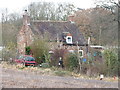
Onion Cottage
A tiny, isolated cottage a little way to the NW of Alveley.
Image: © Richard Law
Taken: 3 Dec 2017
0.13 miles
4
Bridleway in Lyebatch
The bridleway crosses the Alveley Daddlebrook at this low bridge.
Image: © Richard Law
Taken: 3 Dec 2017
0.15 miles
5
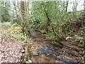
The Daddlebrook in Lyebatch
A little way downstream of Alveley, this brook heads off for the Severn near Hampton Loade.
Image: © Richard Law
Taken: 3 Dec 2017
0.15 miles
6
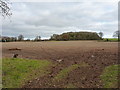
Large field south of Moor House Farm
The copse on the far side of the field lies near Yewtree Cottage, on the road back into Alveley.
Image: © Richard Law
Taken: 3 Dec 2017
0.21 miles
7
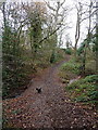
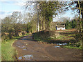
Bridleway to Hampton Loade
A public bridleway passes over this private access road, and eventually comes out on the minor road to Hampton Loade.
Image: © P L Chadwick
Taken: 18 Apr 2010
0.23 miles
9
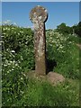
Old Wayside Cross south of Hampton Loade, Alveley Parish
The Butter Cross, old head, shaft & base by the UC road, in parish of Alveley (Bridgnorth District), Hampton Loade - lane North West of Alveley.
Grade II listed. List Entry Number: 1053230
https://historicengland.org.uk/listing/the-list/list-entry/1053230
Scheduled Monument. List Entry Number: 1014889
https://historicengland.org.uk/listing/the-list/list-entry/1014889
To be surveyed
Milestone Society National ID: SABN_ALV01.
Image: © Milestone Society
Taken: Unknown
0.24 miles
10
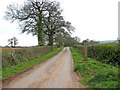
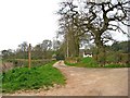
Minor road to Moor House and Alveley
This road forms a long loop, starting and finishing near Alveley's Parish Church. Its most interesting feature is the ancient Buttercross (or Butter Cross if you prefer), which can be seen on the right. More information on this is given in the links below.
Image
Image
Image
Image: © P L Chadwick
Taken: 18 Apr 2010
0.24 miles