IMAGES TAKEN NEAR TO
Stableford, BRIDGNORTH, WV15 5LS
Introduction
This page details the photographs taken nearby to WV15 5LS by members of the Geograph project.
The Geograph project started in 2005 with the aim of publishing, organising and preserving representative images for every square kilometre of Great Britain, Ireland and the Isle of Man.

There are currently over 7.5m images from over14,400 individuals and you can help contribute to the project by visiting https://www.geograph.org.uk
Image Map
Images are licensed for reuse under creativecommons.org/licenses/by-sa/2.0
Notes
- Clicking on the map will re-center to the selected point.
- The higher the marker number, the further away the image location is from the centre of the postcode.
Image Listing (48 Images Found)
Images are licensed for reuse under creativecommons.org/licenses/by-sa/2.0
Image
Details
Distance
1
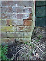
OS benchmark - Stableford, wall at corner of greenhouse
Located at the roadside on a wall described by the OS as "E face wall NE ang of greenhouse Stableford Hall" when last levelled in 1959 at 47.767m above Ordnance Datum Newlyn.
Image: © Richard Law
Taken: 1 Mar 2020
0.05 miles
3
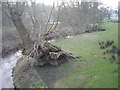
Bridge over the River Worfe at Stableford
Image: © Frank Smith
Taken: 1 Jun 2006
0.06 miles
4
By the River Worfe near Stableford, Shropshire
Looking west from near Stableford Bridge.
Image: © Roger Kidd
Taken: 19 May 2020
0.07 miles
5
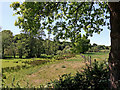
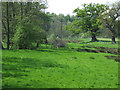
Grazing by the River Worfe near Stableford, Shropshire
A telephoto assisted image, looking south-west from the road. The River Worfe is just visible beyond the sheep.
Image]
Image: © Roger Kidd
Taken: 19 May 2020
0.07 miles
6
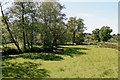
Riverside pasture near Stableford in Shropshire
Looking south-west. The River Worfe meanders a lot here, towards the camera under the trees by the sheep on the left.
Image: © Roger Kidd
Taken: 19 May 2020
0.07 miles
7
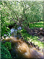
River Worfe near Stableford in Shropshire
Looking west, upstream from Stableford Bridge.
Image: © Roger Kidd
Taken: 19 May 2020
0.08 miles
8
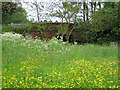
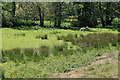
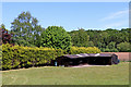
Grazing land by the brook, Stableford, Shropshire
Lush grazing meadows by the brook, which flows into the River Worfe. The image was taken from Stableford Bridge.
Image: © Roger Kidd
Taken: 26 Apr 2007
0.08 miles
9
Farmland with stables near Stableford in Shropshire
Looking east-north-east from the lane. The property known as 'The Walled Garden' is behind the high hedge on the left. The distant woodland is beyond a meandering River Worfe, on land known as Dalepiece Rough.
Image: © Roger Kidd
Taken: 19 May 2020
0.08 miles