IMAGES TAKEN NEAR TO
Brook Lane, BRIDGNORTH, WV15 5HF
Introduction
This page details the photographs taken nearby to Brook Lane, WV15 5HF by members of the Geograph project.
The Geograph project started in 2005 with the aim of publishing, organising and preserving representative images for every square kilometre of Great Britain, Ireland and the Isle of Man.

There are currently over 7.5m images from over14,400 individuals and you can help contribute to the project by visiting https://www.geograph.org.uk
Image Map
Images are licensed for reuse under creativecommons.org/licenses/by-sa/2.0
Notes
- Clicking on the map will re-center to the selected point.
- The higher the marker number, the further away the image location is from the centre of the postcode.
Image Listing (15 Images Found)
Images are licensed for reuse under creativecommons.org/licenses/by-sa/2.0
Image
Details
Distance
1
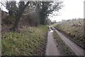
Roughton to Hoccum road
A yellow road, but it looks like a farm track. This is because of the sandy soils nearby and a lot of sand gets washed off fields. The local rocks were laid down in one of the great deserts of Pangea during the Triassic era (younger than Bridgnorth's similar sandstones).
Image: © Richard Webb
Taken: 15 Feb 2018
0.08 miles
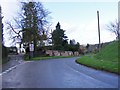
2
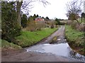
Roughton Junction View
The view from Brook Lane in the hamlet near Bridgnorth.
Image: © Gordon Griffiths
Taken: 4 Mar 2016
0.11 miles
3
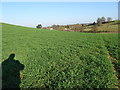
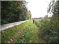
Field Path
The view on the path to Swancote from Roughton in Shropshire.
Image: © Gordon Griffiths
Taken: 27 Feb 2019
0.13 miles
4
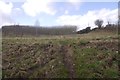
Young trees, Hoccum
Some of the rolling sandstone country here has been planted with trees. Historically this was part of the Forest of Morfe.
Image: © Richard Webb
Taken: 15 Feb 2018
0.16 miles
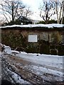
5
Old Milestone in Brook Lane, Roughton
Metal plate attached to stone post by the UC road, in parish of WORFIELD (BRIDGNORTH District), by-road Roughton - Hoccum, Brook Lane, in garden wall, on North side of road. Black Brook plate, erected by the Bridgnorth Black Brook turnpike trust in the 19th century. Seems to have been re-located from opposite Roughton Farm House at SO 7550 9417, possibly moved in war time?
Inscription reads:- : TO WOLVERHAMPTON / 11 MILES / TO BRIDGNORTH / 2½ MILES :
Milestone Society National ID: SA_BNWV02.
Image: © A Reade
Taken: 20 Feb 2006
0.17 miles
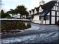
6
Roughton Junction
The view in the hamlet near Bridgnorth.
Image: © Gordon Griffiths
Taken: 30 Jan 2016
0.17 miles
7
The Roughton milestone in its setting
The stone has at some time been removed from its original location by the (old) road through the village, and now forms part of a garden wall. At least it's not fallen victim to 'storage' by the council, so it's still on public view. For a close up, see Image
Image: © Richard Law
Taken: 5 Dec 2010
0.18 miles
8
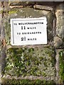
The Roughton milestone - detail
The old milestone has a cast-iron mileage plate bolted to it; the lettering is in need of a little black paint, but reads "To Wolverhampton 11 miles, To Bridgnorth 2½ miles"
Image: © Richard Law
Taken: 5 Dec 2010
0.18 miles
9
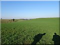
Roughton Footpath
The view of the path near Roughton, Shropshire.
Image: © Gordon Griffiths
Taken: 10 Oct 2016
0.19 miles
10
Hall View
The view to Davenport House, Worfield from the path to Swancote from Roughton in Shropshire.
Image: © Gordon Griffiths
Taken: 27 Feb 2019
0.20 miles